
Temperatures are returning to seasonable highs, well into the 30s in southern New England today and just above freezing in northern New England, with a few snow flurries. For most of us it is a mostly sunny Wednesday.
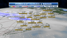
A warm front racing through New York will bring a little bit of snow late tonight, overnight low temperature in the 20s.
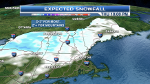
Along the Route 2 corridor of Massachusetts, and points northward, we may have a dusting to an inch of snow during the morning commute tomorrow.
The rest of the day features a mixture of sun and clouds, with a chance of a rain shower south, and snow showers likely north. High temperatures tomorrow also in the 30s to lower 40s. Clearing sky tomorrow night, windy and colder, with a low temperature in the teens to lower 20s.
Friday looks nice, with plenty of sunshine and temperatures recovering to near 40° by afternoon.
Another fast-moving front arrives Saturday with a chance of rain or snow south, and snow likely north.
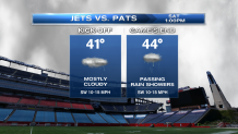
It does not look like a huge impact event, but it may be damp and chilly for the Patriots game at 1 o'clock Christmas Eve Day. Snow showers are likely in Vermont, New Hampshire, and Maine. High temperatures again in the 30s near 40°.
We return to dry weather and sunshine for Christmas day, with a chilly wind from the north, high temperature in the 30s south. and 20s north.
Local
In-depth news coverage of the Greater Boston Area.


A stronger system arrives on Monday with a chance of a wintry mix developing, changing to rain south, and snow north, high temperature in the 30s.
