
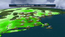
The system that brought a rain-filled couple of days will continue to pull off the coast, bringing any lingering showers with it. So, we showers will taper off through the overnight hours with a partial clearing of the skies. Overnight, lows dip into the upper 40s in northern New England, southern New England will see lows into the lower 50s.
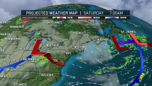
A slight warm-up along with drier conditions stroll in for the weekend. Saturday brings mostly to partly cloudy skies with high temperatures into the lower 60s. A seabreeze kicks up along the coastline which will keep temperatures into the upper 50s for those locations.
Sunday brings another dry day with even warmer temperatures with locations farther inland reaching into the 70s, otherwise, coastal communities will see highs into the 60s under mostly sunny skies. Sunday is definitely the best day out of the holiday weekend for your outdoor plans as high pressure still dominates and steers a system to our south, but does not have that same power for Monday.
Memorial Day Monday brings a broken line of showers in from the west by the mid-afternoon. These will be scattered, so it will not be a washout for our Memorial Day ceremonies with temperatures near 60.
Looking ahead to the rest of the next week, temperatures trend into the 70s just as we change the calendar for the month of June, but the warm-up comes with chances for showers, but again, similar to Monday, not washouts, just spotty showers.
