
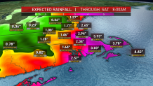
The first major nor'easter of the season is upon us, and as we shake off the rust from a long lull in the pattern, we are reminded again of the highly variable nature of these storms. Our computer guidance has projected anywhere from 2 inches to 10 inches through Friday, with wind gusts varying from 30 to 70 mph. Once again, Mother Nature likes to play cat and mouse with her true leanings, so rest assured that we'll be updating the forecast through every twist and turn.
None of this is made easy by the fact that we are dealing with a Frankenstorm: the combination of a cold front, a coastal storm and a wannabe tropical system, all intertwined to create a bigger storm at sea.
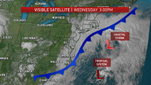
Waves of rain were seen pinwheeling in from the ocean all day on Wednesday (albeit light). We're wary of any and all bursts of intense rain offshore, since what's spinning counterclockwise around the nor'easter will back over us, as the storm wobbles far off Nantucket. Why the stall? A big atmospheric roadblock has set up over northern Maine, and our storm is stuck behind it until the weekend.
The timeline brings the heaviest bouts of rain through Thursday and into Friday. It's a two-day slog through alternating downpours and lulls that may cause localized flooding of roads, intersections and basements. It's also here that the variability shows its true colors. We could see as little as 1 inch of rain in Southern New Hampshire and up to 5 on the Cape/Islands, with everyone else lying in between.
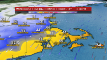
Wind is the other dominant feature in the storm. Gusts may accompany any heavy rain burst, but it's the sheer persistence and duration of the wind that may ultimately cause the isolated power outages across eastern and southeastern Massachusetts. Saturated ground and nearly fully-leafed trees aren't helping the cause, either. Some could eventually give way as the storm wears on.
Coastal flooding has been a back-and-forth issue. Astronomically LOW high tides (sounds odd, I know) have been something we've been headlining for a minor flood threat, but due to the sheer size of the storm, the "fetch" (wind blowing the ocean) is drawing water from as far away as Nova Scotia! As Chris Gloninger noted in a tweet, this causes the water to stay piled up along the coast -- even at low tide.
Now, concern revolves around the potential for moderate coastal flooding on Nantucket by Thursday night. There's also the possibility of minor flooding on all east-facing beaches from Plymouth to Cape Cod. This will all unfold during multiple tide cycles from Thursday through Friday. Wave heights of 15-20 feet will compound the matter, too, turning the surf to froth and chewing away all that wonderful sand that accumulated during the summer.
The endgame comes on Saturday. We'll turn the winds around, back off the rain in the morning and potentially brighten the skies before sunset (not making any promises yet). Sunday is the pick of the two weekend days... too bad we couldn't swing the Patriots game to that time slot!
