A powerful system will track into the Canadian Maritimes overnight Saturday into Sunday after leaving portions of western and northern New England under 6-12” of snow.
We’ll see colder air flowing into New England Saturday night along with a northwest wind gusting over 40 mph at times.
A changeover to snow is also likely from west to east this evening with a coating to an inch or so south, more possible across the higher terrain of southern New England, with the highest amounts across Vermont, New Hampshire, and Maine.
Precipitation will slowly cut off late Saturday night with northern Maine holding onto the last bursts of snow through after midnight.
Get Boston local news, weather forecasts, lifestyle and entertainment stories to your inbox. Sign up for NBC Boston’s newsletters.
Lows tonight will fall to around 20 south, and teens north with wind chills flirting with 0 by Sunday morning!
Winds will subside during the day Sunday but be prepared for a winter chill along with some sunshine.
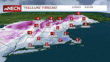
A stray flurry or snow shower is possible across the mountains, one may sneak south, but most of us should remain dry. Highs reach the mid to upper 30s south, and mid 20s to freezing north, but the gusty northwest wind will make it feel colder.
Next week will feel more like Spring as winds turn more out of the south on Monday.
Our exclusive 10-Day forecast features a mostly dry work week with overall temperatures in the 40s and 50s.
Localized sea breezes may cool off the coast at times.
Have a great night and don’t forget about pushing those clocks ahead one hour tonight and changing out your smoke alarm batteries!