
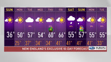
High pressure will provide the region with another cold night under a mostly clear sky as it slides southeast of New England Sunday night. The good news is that we won’t be as cold and windy as Saturday night, but we will start to see winds kick up a bit out of the southwest during the night.
Lows Sunday night drop into the teens north, and mid 20s to around 30 south, colder across the interior valleys.
Average for this time of the year is 45 degrees in Boston, and we’ll be exceeding that all week. Our spring vibes hype up by the end of our work week as we track our highs reaching 60s.
Get Boston local news, weather forecasts, lifestyle and entertainment stories to your inbox. Sign up for NBC Boston’s newsletters.
After a chilly start, Monday will feature milder temperatures with a good amount of sunshine. Winds may pick up a bit in the afternoon out of the west/southwest, but overall, we’re expecting a mild day with highs around 50 south, and mid 40s north, cooler along the south coast of New England and south facing shorelines.
Snow chances near the Canadian border pop up Monday night, and return on Tuesday night.
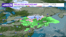
Another mild day is on tap for Tuesday with clouds increasing from the north as the weak frontal boundary approaches.
This may kick off a few snow/rain showers across the higher elevations late Tuesday into Tuesday night, but southern areas will remain mostly dry during the daylight hours, with the increasing chance for showers during Tuesday night.
Highs reach the mid 50s south, and mid to upper 40s south.
After slightly cooler temperatures Wednesday, we’ll see much warmer temperatures moving into the area Thursday and Friday with highs approaching the 60s Thursday and possibly reaching 70 degrees on Friday!
One thing to watch though is an offshore storm system which may try to sneak into southern New England on Thursday as it tracks to our south, keeping a slight chance of rain showers for the south.
While we’ll continue to monitor that system, our chances for showers next weekend seem promising -- though, there is still plenty of time between now and then for things to change.
Boston Sports


A bigger storm could bring showers next Saturday, but considering we’re still a week away from that, we’ll keep a pin on it to keep tracking its path and watching its precipitation types as the week progresses.
Astronomical spring begins next Sunday, March 20, and our temperatures seem to reflect it forecasting upper 50s by then.
Stay tuned!
