
As we look ahead to next week, all eyes are on how Hurricane Isaias moves across the Atlantic and up the eastern coast of the U.S.
The hurricane continues its journey across the Carribbean and into the Bahamas on Friday night, moving east and along the coast of Florida on Saturday into Sunday. Then the storm will head toward New England, but the exact track is still uncertain.
A First Alert has been issued for Tuesday and Wednesday, as we are more confident that the storm will bring in heavy rainfall and gusty winds as well as some rough surf at the very least sometime Tuesday into Wednesday. Stay tuned for important updates from the First Alert weather team.
Before Isaias arrives, we're looking at a warm Friday and Saturday and the possibility of storms for some on Sunday.
The morning rain across the south coast continues to move out on Friday afternoon and our weather improves. The humidity lowers from north to south a bit and the clouds also break apart for southern New England on Friday afternoon.
Local
In-depth news coverage of the Greater Boston Area.


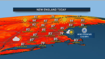
There is a chance for a pop-up shower south of the Massachusetts Turnpike and possibly along a seabreeze boundary. Most of us will stay dry, though. Highs will be in the mid-80s inland and around 80 on the coast. Northern New England continues to have refreshing dewpoints in the 50s and mostly sunny skies. Late Friday afternoon some isolated showers and thunderstorms will pop up across the north country, dissipating after sunset.
Get Boston local news, weather forecasts, lifestyle and entertainment stories to your inbox. Sign up for NBC Boston’s newsletters.
This weekend, high pressure will settle into the northeast. Most of us stay dry for Saturday and this is the pick of the weekend, with sunshine, low humidity, highs in the mid-80s and cooler temps at the coast.
On Sunday, a warm front will lift from the south during the afternoon, so our clouds increase and the humidity increases. Scattered showers and thunderstorms are possible, especially across western New England by late afternoon. Some storms could be severe with damaging wind and large hail.
