Tuesday may end up being the pick of the week, as far us uniform, nice, mild weather goes for most of New England. We have some challenging times ahead starting later Tuesday night.
Most of us have sunshine Tuesday afternoon, but there has been a stubborn layer of altocumulus clouds stuck from central Vermont to central and eastern Massachusetts. These clouds are slowly decaying the rest of the day, though. And for the second day in a row, a “Red Flag Warning” for high fire danger, focused on the entire Granite State of New Hampshire and most of southern Maine. That means dry air with breezy weather conditions favor explosive growth of any brush fires that develop on our dry ground, most often started by cigarette butts and embers from brush burning.
The dew point temperatures are only in the 10s and 20s, with air temperatures near 70 degrees, putting relative humidity as low as 10%. But help is on the way in this department. The first showers are expected to be scattered, expanding from northwest to southeast before dawn Wednesday as milder and somewhat more humid air starts moving into New England, then showers should break entirely for several hours centered around the middle of the day.
By evening, new showers and embedded thunderstorms expanding east out of Upstate New York will sweep across New England, and while the greatest chance for strong or severe thunderstorms will remain focused in central New York to the southern tier, some strong storms may wander east through the Capital District and into New England.
Get Boston local news, weather forecasts, lifestyle and entertainment stories to your inbox. Sign up for NBC Boston’s newsletters.
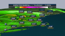
Thursday and Friday, a storm center strengthening over the Great Lakes then swinging east across New England will bring periodic showers, rain and thunder – most likely focused primarily in the second half of Thursday and first half of Friday, but the timing is still unclear enough that our team is advising both days be viewed as showery until we gain more clarity.
Either way, New England will sit right on the tight boundary between cool and mild air – such boundaries are a classic breeding ground and pathway for storms to follow – so we should see some rather dramatic differences in temperature across the region, from 70s possible in southwestern communities like Connecticut, to highs only in the 40s in Maine or northern New Hampshire.
Local
In-depth news coverage of the Greater Boston Area.


The storm clears New England for the weekend, leaving a fair sky Saturday with just a slight chance of a shower, and perhaps sun fading behind some building clouds Sunday, with again only a slight chance of a shower.
Next week likely will bring renewed chances for showers, but a generally mild pattern is expected to continue.