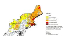
Beautiful weather for us in New England means a worsening drought. The new drought report issued by the National Drought Mitigation Center at the University of Nebraska-Lincoln, the U.S. Department of Agriculture, and the National Oceanic and Atmospheric Administration reports that much of New England is in a severe to exceptional drought.

But this rain-free pattern is good news for working outdoors or enjoying the nice rebound to temperatures close to 80 degrees for a few days.
With plenty of sunshine, at times shining through the clouds on the northern edge of the remnant of Tropical Storm Beta, we are well into the 70s and low 80s on Thursday afternoon, cooler to the north.
A weak front cutting from the Northeast Kingdom of Vermont through central Maine is spawning heavier clouds, with a few showers or even a thunderstorm in isolated areas north.
Get Boston local news, weather forecasts, lifestyle and entertainment stories to your inbox. Sign up for NBC Boston’s newsletters.
Wind is generally light from the west and southwest. The surf advisories have all expired.
Local
In-depth news coverage of the Greater Boston Area.
The front in Maine dips south a bit overnight Thursday night, so low temperatures in the crown of Maine get down to the 30s, but for most of us we are going to bottom out in the 50s and lower 60s, with pleasant sleeping weather continuing.
That same front lifts north on Friday, again with a few showers or thunderstorms north, but plenty of sunshine for most of us, with high temperatures near 80 degrees once again.
The weekend is a bit challenging. There is a weather system in southeastern Canada and the remnant of Tropical Storm Beta off to our south. Humidity is going to come up, with a mixture of sun and clouds, and most of us should be near 80 degrees both days Saturday and Sunday.
It will be a nice weekend for checking out the foliage, near peak toward the Canadian border, and coming on strong elsewhere following that frosty weather a few days ago.
The best chance for rain probably comes in Sunday night and Monday. We may have a front stall from southeastern Canada to the southeastern U.S., with the possibility of a little relief from the drought in the form of scattered downpours and thunderstorms early next week. Stay tuned to the latest here in our First Alert 10-day forecast.


