An arctic frontal boundary will produce gusty winds along with briefly heavy snow squalls Saturday evening as it passes through the region. Snow will be briefly heavy causing whiteout conditions for some as the frontal boundary rapidly passes through the area.
We can expect visibility to briefly drop to a quarter mile or less across portions of central New England and southern New England between 4 p.m. and 8 p.m., which will also cause dangerous conditions along the roadways.
Get Boston local news, weather forecasts, lifestyle and entertainment stories to your inbox. Sign up for NBC Boston’s newsletters.
The Massachusetts Department of Transportation said just after 5 p.m. Saturday that it has 680 pieces of equipment deployed in snow and ice operations statewide.
The speed limit remains reduced to 40 mph on Interstate 90 from New York to mile marker 41 in Westfield, MassDOT said.
The transportation agency is urging drivers to use extra caution on the roads and reduce speed, as conditions and visibility can quickly deteriorate.
Some communities will be spared with just a few flurries and snow showers, but for those of you that do encounter one of these squalls, please be very careful or simply wait it out until the frontal boundary passes through your area.
Most of the action will be exiting the southern New England coastline by 8 p.m. as the front pushes off shore, but we could still see some slick spots leftover on some of the untreated surfaces through the overnight hours as much colder air moves back into the region via a gusty northwest wind.
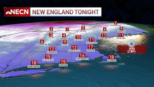
Overnight lows will be in the teens south, single digits north with wind chills values near to around 0 south, below 0 north.
Sunday will feature cold temperatures with a good deal of sunshine as high pressure builds into the region.
It’ll be a bit breezy in the morning with wind chills starting off in the single digits south, below 0 north but those winds will diminish by the early afternoon hours.
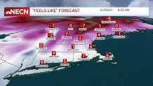
Highs reach the mid 30s south, upper 20s to around freezing north.
Southerly winds will kick up late in the day Sunday as high pressure south of the region moves off shore. This will usher in much milder air once again for the region with highs reaching the 50s on President’s Day (Monday) south, the 40s north with clouds and sun.
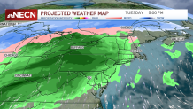
Our next system arrives during the day Tuesday with mainly rain south and a mixture of snow, sleet, and rain south.