
Don't let the sunshine fool you, winter's here to remind us of the date in the calendar as we had a 47 degree drop Saturday morning after reaching 61 degrees at 7 a.m. in Boston Friday. Now we’re left with wind chills in the 20s and snow!
Our snow keeps shifting southeast, while light to moderate at times for many, scattered snow squalls remain possible. These snow squalls reduce our visibility, bring sudden intense bursts of snow that precipitate rapid accumulating amounts.
These, unlike blizzards, only last minutes rather than hours. Along with much dry air with this system, snowfall amounts remain limited. We could still be adding from a coating to an inch in eastern Massachusetts, while the west could see up to 2 inches. Higher amounts in the Berkshires and as we make our way north into the mountains the accumulation amounts may add up from 3-4 inches.
Slick conditions will remain through tonight and tomorrow morning, as much of the moisture left by yesterday’s rain over the roads may also be freezing up. Clear skies will remain tonight into tomorrow.
Get Boston local news, weather forecasts, lifestyle and entertainment stories to your inbox. Sign up for NBC Boston’s newsletters.
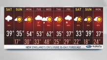
Our highs tomorrow will remain in the 30s and feel in the upper 20s along active winds. Sunny skies will continue through Monday with increasing clouds in the evening before our next system moves in bringing rain. Our active rainy days will be Tuesday afternoon into Wednesday early morning.
Thursday night sets us up again for the chance of showers into Friday, this time we could be having the slight chance of a wintry mix moving along as temperatures drop. The mildest day in the 10-day forecast will be Wednesday, another afternoon where we climb to the low 60s.
