
The powerful storm which delivered strong winds, heavy rain, and higher elevation snow to the region is rapidly coming to an end Tuesday afternoon as it quickly tracks through northern New England and into Canada.
Many areas received around an inch or more of rain, higher elevations saw several inches of snow, and the coast received the strongest wind gusts in excess of 50 to 60 mph, especially across southeastern New England and coastal Maine.
Tuesday afternoon, we’ll see improving conditions with some sunshine and a few "spot" rain showers across the south, with steady rain showers exiting the north. The higher elevations of northern New England will see some snow showers continue through the afternoon and into the overnight hours, where we could see a coating to a couple of inches of snow by Wednesday morning.
Winds will also continue to crank from the west on Tuesday afternoon, but we're not expecting any damage going forward as they diminish somewhat later Tuesday into Tuesday night. Highs reach the mid to upper 50s south, upper 40s to low 50s north, with cooler temperatures across the higher elevations.
Get Boston local news, weather forecasts, lifestyle and entertainment stories to your inbox. Sign up for NBC Boston’s newsletters.
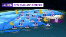
Skies will clear out Tuesday night as high pressure builds into the region, with the exception of the higher elevations of western and northern New England, where we’ll see upsloping winds produce some snow showers. Winds will remain active out of the west, with gusts up to 25 mph at times. Lows will be in the mid 30s to 40 south. It will be around freezing to the mid 30s north.
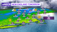
We’ll see breezy conditions Wednesday, with some sunshine and afternoon clouds, but temperatures will be close to seasonable levels -- in the 50s south and upper 40s to low 50s north.
A warming trend will commence Thursday and Friday, with the risk for a few showers across northern areas Thursday as a warm front pushes through the region. Highs will reach the 60s Thursday and upper 60s Friday!
Local
In-depth news coverage of the Greater Boston Area.


A back door cold front looks to cool things off a bit over the weekend, but so far it is looking mostly dry and seasonable, with no major weather issues.
