
We have had two days in a row with 70 degree temps in Boston, but the party is over Thursday as a backdoor cold front continues to push onshore and farther inland.
Temperatures across the Merrimack Valley, New Hampshire, and Maine will be in the 40s to 50s with drizzle near the coast and clouds leading to stable air.
Across southern Vermont, western Massachusetts, Connecticut, and western Rhode Island, we will feel like summertime. Temperatures jump into the 70s to low 80s in the valleys with some breaks in the clouds. Humidity will jump up and this means unstable air.
By dinnertime we have thunderstorms marching towards New England and arriving in the unstable airmass around Hartford, Connecticut. Some storms may be severe with damaging wind and hail.
Get Boston local news, weather forecasts, lifestyle and entertainment stories to your inbox. Sign up for NBC Boston’s newsletters.
By the time the storms head towards Worcester, Massachusetts, an isolated severe storm is possible. Then the line heads towards Boston and breaks apart and weakens as stable air calms down the energy.
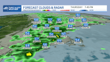
All the rain and storms move offshore overnight.
Local
In-depth news coverage of the Greater Boston Area.


Friday morning we have decreasing clouds and temperatures in the 60s for the Red Sox Home Opener in the afternoon!
Our dry weather continues into Saturday with highs around in the 60s and some sun. Scattered showers return for Saturday night into very early Sunday. It looks like we dry out in time for those Easter egg hunts late morning to afternoon. Mostly sunny skies are anticipated for Easter Sunday with highs in the 50s and a breeze.
The Boston Marathon forecast has improved! Temperatures should be cool in the 40s in the morning, with 50s by afternoon and developing sea breezes. Our next storm system should hold off until overnight Monday into Tuesday.
