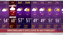
After enjoying a lovely afternoon with sunny skies and dry weather, we’ll continue having clear skies Wednesday night, which will allow for radiational cooling. This means our surface will cool into the 30s south and 20s north, letting some frost form again as we wake up.
And even though we’ll continue with dry weather Thursday, our highs will be lower than Wednesday. We’ll be staying in the 50s with increasing cloud cover through the afternoon hours.
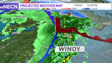
We’ll be on First Alert Friday, as a low pressure system is moving in with embedded thunderstorms, gusty winds and widespread showers. Our gusts inland are expected to exceed 25 mph, while in the southeast we could be watching speeds over 45 mph.
Get Boston local news, weather forecasts, lifestyle and entertainment stories to your inbox. Sign up for NBC Boston’s newsletters.
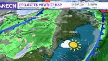
The same low that will be advancing over New England this Friday has already produced storms today over the plains. It will produce snow over the midwest and drop temperatures significantly over its path. Our highs will drop into the mid 50s by Saturday, down to the upper 40s and 50 by Sunday and down to the 40s by Monday and Tuesday.
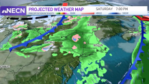
Our total rainfall amounts are expected to remain between 1 to 1.5 inches by the end of Friday. Even though Saturday is expected to remain mostly dry, showers will be moving in during the evening hours but exit for Sunday. The northern states, however, will likely continue to watch for showers on Sunday morning.
Next week will begin on the cold side; highs will top out in the upper 40s and lows will drop into the 30s in the south, 20s inland and possibly watch some teens in northern Vermont, New Hampshire and Maine.
Wintry precipitation is also expected for Monday, with total amounts ranging between 1 to 2 inches of snow in the mountains.