
Showers will come to an end Sunday evening, and we’ll see clearing skies and chilly temperatures moving in for the overnight. Winds will also diminish as high pressure moves into the region which will allow for some of the traditionally colder areas to cool off quickly due to radiational cooling (dry air, low dewpoints, and light winds).
Lows Sunday night drop into the mid 30s to around 40 south, locally cooler, and in the mid 20s to low 30s north.
Monday is looking fantastic for the Boston Marathon, but it will start off cool. We’ll see lots of sunshine in the morning with light winds out of the west, but those will shift out of the east during the late morning hours. Highs will reach the low to mid 50s south, mid 50s north with clouds on the increase during the afternoon.
A coastal low will rapidly develop and track through New England late Monday night and Tuesday. We’re expecting heavy rain along with strong winds along the coast, which may bring about a few power outages. This will also coincide with the Tuesday morning commute which is why we have issued a First Alert on the 10-Day forecast.
Get Boston local news, weather forecasts, lifestyle and entertainment stories to your inbox. Sign up for NBC Boston’s newsletters.
The higher elevations across interior southern New England and into northern New England will likely see some snow out of this as well, especially the Green and White Mountains.
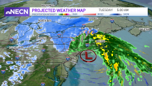
Snow totals will depend on the storm’s exact track, which is expected to be an inside runner dissecting the region. Our exclusive forecast system is forecasting several inches across the higher terrain, but being mid-April, there is still a bit of uncertainty on how things will pan out due to storm’s exact track.
Local
In-depth news coverage of the Greater Boston Area.


Thereafter, we’ll see a mid-week warmup with temperatures returning to the 60s! Stay tuned!
