A cold front drops south through New England and is bringing a transition to a wintry mix of freezing rain, sleet and snow from north to south late tonight into Friday morning as cold air pushes in.
Timing of the transition, as well as the snowfall amounts depend on location. While northern New England has already received its share of snow today in the far northern country, scattered rain has filled in for much of western New England and more fragmented rain has affected eastern New England.
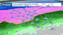
Freezing Temperatures Hit During Morning Commute
From being in the 40s today, our temperatures will take a dramatic drop to the 20s by tomorrow morning north and drop slowly south through the early afternoon into the evening. Rain will switch over to sleet by 4 a.m. from the lakes region north of the Merrimack Valley and towards western Mass. While the temperatures will remain in the upper 30s early in the morning, the earlier commuters won’t suffer from freezing just yet, but by 7 a.m., we’ll see those temperatures reaching near 32 in Worcester, northern Essex County and Middlesex counties. This could cause flash freezing in some areas. While the far southeast will remain with plain rain, we’ll already be dealing with slick conditions for many across I-495, I-95, Routes 2 and needless to say that much of the north.
Get Boston local news, weather forecasts, lifestyle and entertainment stories to your inbox. Sign up for NBC Boston’s newsletters.
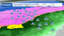
Transition to Freezing Rain and Sleet Continue Into Evening Commute
In order to watch the southern cities reach near freezing point, we’ll likely have to wait until noon or a bit after to see the low 30s and upper 20s. The Cape and Plymouth County are likely watching the upper 20s and 30s after 6 p.m. This means that the morning commute won’t be too much trouble for the southeastern areas, but it will for the evening commute as freezing rain and possible sleet fills in.
Our weekend is looking calm and sunny, although cold with highs in the 20s. While next week will bring more quiet days, highs in the 30s and some 40s through the week with the most active day possibly being next Friday. Take a look at our Exclusive 10-day forecast and stay tuned for the updates.
Sign up for our Breaking newsletter to get the most urgent news stories in your inbox.