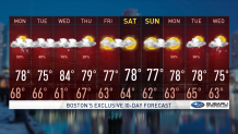
After a rain-saturated Saturday, Sunday will be a bit more of the same.
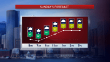
There is no “sun” in our Sunday across much of the region. Showers and thunderstorms continue to roll through. I'm not expecting a widespread event, but it is another day to take the proper precautions.
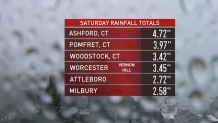
Before I dive into Sunday and the next few days, Saturday we saw impressive rain totals just from the day storms. For example: 4.7 inches in Ashford, Connecticut, and 3.45 inches in Worcester-Vernon Hill. Torrential downpours, large hail and numerous lighting strikes came along with these cells that rolled through. After numerous thunderstorm warnings and flash flood warnings, the instability died down, which gave a much-needed break to the flooded areas.
Get Boston local news, weather forecasts, lifestyle and entertainment stories to your inbox. Sign up for NBC Boston’s newsletters.
The story continues... the front (the culprit) will remain stationed over southern New England on Sunday with an approaching disturbance. This is why we’re seeing all this unsettled weather, and it’s along this system and points north that is our main focus. We’ll see another round of scattered showers and thunderstorms.
Sunday, fortunately, will see more clouds than Saturday, with less opportunity for the sun to come out and fuel the risk for severe thunderstorms, giving way to less instability. We do, however, expect heavy rainfall with these cells, and additional rain accumulation. Heavy rainfall will continue to be a threat. The areas under the greatest risk for scattered severe storms will be Connecticut/Rhode Island and southeastern Massachusetts. Meanwhile, areas along and south of the front will be in the warm sector, leading to temperatures in the 80s with high humidity, and dewpoints in the lower 70s. No bueno. Areas to the north of the boundary will enjoy less humidity and temperatures on the cool side, in the 70s, maybe falling into the upper 60s.
Looking ahead, the first half of next week is looking unsettled, with rain and a chance for thunderstorms. The latter part of the week we're looking forward to drier weather.
Local
In-depth news coverage of the Greater Boston Area.

Let’s be careful out there. Please stay safe.
Keep in mind… avoid flooded roadways. Turn around, don’t drown. And when thunder roars, go indoors.