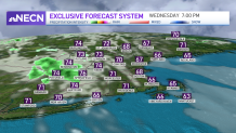
Wednesday is a beautiful day in New England!
We started off with more sun before watching increasing cumulous clouds. We have a northeast flow that, along with humidity, promotes low-level clouds.
As these marching clouds diminish in the afternoon, we’ll watch more high- and mid-level clouds filling in through the evening off the west.
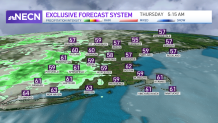
With mostly dry conditions through late afternoon, scattered showers creep in over western New England Wednesday evening. Near dawn, showers continue and we could have some early morning showers expand through central and eastern Massachusetts towards southern New England stretching to late morning.
Get Boston local news, weather forecasts, lifestyle and entertainment stories to your inbox. Sign up for NBC Boston’s newsletters.
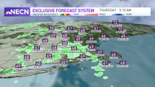
By lunchtime Thursday, our weather should have improved significantly, but we’ll see a second and more widespread round of showers.
For Thursday night into Friday morning, we could be watching more thunder. These storms pop up in northern New England, primarily Vermont, and then they travel south through Friday morning.
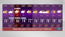
Our team has issued a First Alert for Friday afternoon due to the chance of severe storms affecting the evening commute, as well as any outdoor plans. The storm could bring heavy rain, storms, wind gusts and the chance of small hail.
Mid-level dry air will fill in and improve conditions for the weekend. A cold front will bring more seasonable weather and our temperatures will slightly drop. A chance of showers may crop up on Saturday but Father’s Day is looking fabulous for now.