
Our first snow-maker of the year has come and gone without much fanfare. An ocean storm remained far out at sea and it passed by Monday night. Only 1 to 2 inches of snow fell across Nantucket thanks to very dry air in place for most of New England, even on Cape Cod.
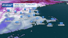
The roads are icy there on the Island on Tuesday morning, while everyone else is dealing with bitter cold but at least dry pavement. Lows reached the single digits and teens, with wind chills around zero to 10 degrees south. We trade the clouds and mild temps in for the cold and sunshine of Tuesday. Yes, sunshine!
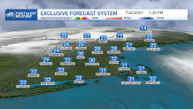
Tuesday afternoon we warm to around freezing, but with the sun it will feel amazing. Tuesday night’s lows will be cold again in the teens and 20s, but the wind will be near calm.
Get Boston local news, weather forecasts, lifestyle and entertainment stories to your inbox. Sign up for NBC Boston’s newsletters.
We have another system heading in for Wednesday, with increasing temps thanks to a southerly wind. Scattered rain showers are likely in southern New England, with a changeover to light snow in the mountains as colder air returns rather quickly Wednesday night into Thursday.
Highs will be in the upper 40s Wednesday, then drop back to the 30s Thursday. Temperatures in the low 30s stick around through Friday as we watch our next storm system.
Local
In-depth news coverage of the Greater Boston Area.


This one has a wide variation of outcomes in the forecast models, so we can’t lock in even snow versus rain for Boston just yet. We are confident that we will see precipitation in some form for Friday, so we have issued a First Alert. Stay tuned for updates to the track, wind speeds, and snow totals as the week goes on.
Temperatures fall to the 20s for highs as high pressure builds in briefly Saturday.
On Sunday we have another wintry mix, with temperatures around 40. Next week looks quiet after this series of systems, with highs remaining in the 20s to 30s through the 10-day forecast and no other First Alert days.
