
It’s nice to get the sun back. Even if it is for only a day. For a winter that hasn’t seen much white, we’ve surely been seeing a lot of gray.
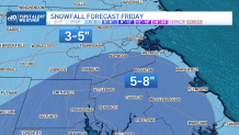
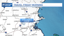
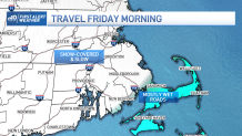
The next storm system has been flipping and flopping like a fish out of water. What seemed like a minimal event is looking more like a solid dose of snow. We’re preparing for slow travel with steady and possibly heavy snow on Friday morning. In fact, based on current projections and snowfall intensity, it looks like a lot of delays and cancellations are in order.
Get Boston local news, weather forecasts, lifestyle and entertainment stories to your inbox. Sign up for NBC Boston’s newsletters.
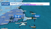
Our storm system is zipping through quickly, so this precludes any amounts near a foot.
That said, there will be a period of time where snowfall rates may approach an inch per hour between 5 and 8 a.m. – right in the heart of the morning commute. For many, this will be our first widespread snow event tangled up with a morning commute.
Take it slow and easy if you have to travel. As snow tapers off early in the afternoon, the evening commute looks a lot better.
The timeline brings the snow in very late Thursday night – more toward the wee hours of Friday morning. Pacing picks up through the early morning, tapering through the late morning and abruptly ending in the early afternoon. No ice is expected this time around (thankfully), but the outer Cape and Islands will mix with rain given the track of the storm and the lack of deep cold air across the Commonwealth.
Local
In-depth news coverage of the Greater Boston Area.


After the storm, cold air will rush in for Saturday. We’re seeing things turn back around on Sunday as high reach back to the 40s.
That too will be short-lived. Much colder air is traveling in early next week, so prepare for the deep freeze to reach us by Tuesday.
