
The NBC10 Boston First Alert weather team has issued a First Alert on Friday for a potent storm system taking shape later this week.
This system has origins to storms that hit north Texas Tuesday morning and feet of snowfall across the California Sierra.
The finale of this system moves across New England on Thursday night through Saturday and will likely bring a good dump of snow across New England. This will provide an excellent base for Ski Country and will likely be plowable in parts of Vermont and New Hampshire.
What will happen across southern New England still provides the biggest question mark.
Get Boston local news, weather forecasts, lifestyle and entertainment stories to your inbox. Sign up for NBC Boston’s newsletters.
This setup is particularly interesting because as the low approaches, a warm front noses its way in. This will bring milder temperatures and dewpoints in the 50s. Freezing rain and sleet will fall across the Appalachians and central Pennsylvania. While most models agree that rain will surge into southern New England, the latest trends support a mix of rain and snow across Worcester County and the 495 corridor.
Where will the rain-snow line be?
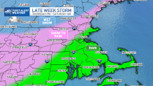
Some guidance has the low tracking further west, across central Massachusetts and interior portions of New England, resulting in warmer air and more rain for the Boston metro area. On the other hand, the track of the core of the storm to the east would bring snow closer to the coast. Both are still very viable options for the late week storm.
Local
In-depth news coverage of the Greater Boston Area.


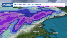
How many inches of snow will we get?
What does look very likely is accumulating and plowable snow through western Massachusetts, the Berkshires, the Presidentials and interior sections of Maine.
Here's an early look at projected snowfall totals:
This storm is still undergoing rapid changes. Check back with the First Alert weather team all week for continual updates as the forecast evolves.
Be prepared for your day and week ahead. Sign up for our weather newsletter.
