
Matthew is maintaining his strength as a powerful category 4 hurricane with winds of 145 mph. There was some weakening overnight Saturday as the storm was stationary — causing the warm water at the top of the ocean to mix with the cooler water at the bottom of the ocean. The hurricane's forward movement has since increased from 0 to 5 mph. If the current forecast is to verify, the eye of the storm will pass between Haiti and Jamaica. This track is the "worst case scenario" for the western part of Hispaniola. Not only will the island see destructive winds, the mountainous regions may see 40 inches of rain, which will lead to deadly flash flooding.
As Matthews moves north, it will stay over warm waters — spending little time over the land. This is bad news for the Bahamas. The islands will likely see a MAJOR hurricane by midweek (Category 3 or stronger).
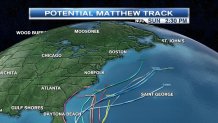
After the Bahamas, Matthew will continue to move north. Forecast models are coming into better agreement that the hurricane will stay off the east coast.
That DOESN'T mean we won't see any impacts. We might see some of the moisture pulled into New England by next weekend. With high pressure over southern Canada and the hurricane offshore, that should be a tight enough pressure gradient to give us some gusty winds as well. Stay tuned!
