
It's another fabulous afternoon in New England! With a high-pressure system over Nova Scotia, our temperatures remain influenced by the south flow. Onshore flow in the coastal communities brings cooler temperatures in the 60s, 70s inland with near mid-70s in the far west and northwest. While mid/high-level clouds take over, the sun continues to bring a battle and allow for a fabulous dry afternoon.
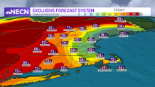
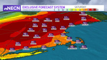
Our chance of heavier rain, however, increases late Friday and overnight Saturday in western and southern New England, with another chance of storms in western and northern New England Saturday afternoon. This is why we've issued a First Alert for Saturday, when things could get stormy in many areas.
As the daytime heating may fuel storms, some of these may grow strong and enhance the chance for frequent lightning, localized wind gusts and some hail. With the cold front moving through Saturday night, we'll see a slight cool down for Sunday but another rise in temperatures on Monday.
Get Boston local news, weather forecasts, lifestyle and entertainment stories to your inbox. Sign up for NBC Boston’s newsletters.
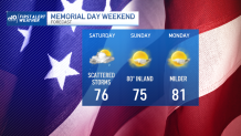
Overall outdoor plans for Saturday afternoon should be cloudy but mostly dry in the south. Storms will move along the north and west mid-afternoon to late evening, and some isolated storms may move into central New England, exiting Saturday night to bring fabulous weather for everyone on Sunday and Monday.
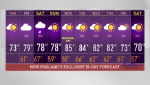
Next week features above average highs with temperatures running up in the 80s much of next week. A backdrop front may bring cooler temperatures for us on Tuesday/Wednesday but we’re still tracking overall comfortable temperatures for western communities. Our temperatures cool down by the end of next week with highs down to the 70s again.
Weather Stories


Be prepared for your day and week ahead. Sign up for our weather newsletter.
