The mild weather continues for a couple more days before a blast of cold air returns. The north country had some snow from snow squalls early Thursday night, and those showers have dissipated Friday morning. Some new slick spots are found there as well as across interior New England where temperatures dropped to below freezing again.
A mix of clouds and sun will be around for all of us Friday as high temperatures reach the upper 30s north to the 40s south. Again, some lucky spots in southern New England will hit 50 degrees.
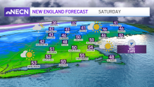
It will be even more mild on Saturday as highs will be in the 50s, bringing us another taste of spring and more melting.
Get Boston local news, weather forecasts, lifestyle and entertainment stories to your inbox. Sign up for NBC Boston’s newsletters.
A weak system passes by to the north tonight into Saturday, swinging in a cold front. This system brings light showers, light snow or a light wintry mix for us.
The main change is going to be colder air for Sunday. Highs for Sunday dramatically fall into the 20s, which means if we see any precipitation it will be in the form of snow.
An offshore storm develops and rides along the cold front that stalls to the south. Southeastern New England may pick up a couple inches of snow gradually Sunday. Then ocean-effect snow showers are possible on Cape Cod Monday.
Valentine’s Day will be sunny elsewhere, but really cold with highs in the low 20s.
This cold snap is short-lived as we see modifying temps for midweek.
Another warm-up may head our way for the end of next week with highs returning to at least the 50s.