
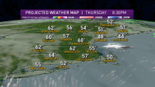
It took a while to shake low clouds and fog Thursday, but most of us made it to the 60s and 70s in warmer spots by the afternoon.
In northern Vermont, it has been sunny all day, with record highs of 70 to 75 degrees. On the Maine coast, we barely made it past 50.
With the warmer and more humid air in place, we stay mild, with patchy dense fog again Thursday night and lows in the 50s to near 60 degrees, with record high low temperatures possible Friday morning.
Get Boston local news, weather forecasts, lifestyle and entertainment stories to your inbox. Sign up for NBC Boston’s newsletters.
A storm system responsible for widespread severe weather in the southeast United States on Thursday afternoon will eject a piece of atmospheric energy and moisture northeast toward the northeast, arriving here Friday morning with downpours and even the potential for a gusty thunderstorm in southeast New England before noon, with a distinctly humid feeling to the air.

By afternoon, the sun should break out from west to east and result in a rapid temperature rise through the 60s and perhaps even 70s, with the coast being the last to see the rebound but enough moisture lingering in the atmosphere that a renewed shower or downpour is possible later Friday afternoon as a cold front approaches.
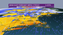
Wind may be an issue, with gusts from the south past 40 mph where the sun does break through.
The sweeping cold front late Friday will deliver a new wind from the northwest and a new air Friday night into the weekend, with snow showers in the northern mountains and North Country Friday overnight into Saturday morning, and Saturday looking much cooler with a fresh breeze under a fair sky, but still undoubtedly the pick of the two weekend days.
Local
In-depth news coverage of the Greater Boston Area.


A storm system approaches from the west Sunday, bringing rain from west to east Sunday mid-morning, lasting through the remainder of the day and keeping temperatures down. In fact, those temperatures will be so cold that snow is expected in some of northern New England!
Right now, our First Alert weather team is expecting as much as three to six inches of Sunday snow from the higher terrain of the Presidentials east through the Maine mountains, with four to eight inches possible in northern Maine.

Although Monday brings sun, that bright sky comes immersed in another shot of cool air behind our departing storm, but dry weather will last until midweek showers and rain late Wednesday through Thursday, with the entirety of next week cooler than this one in our exclusive First Alert 10-day forecast.
