
The change in air is noticeable across New England on Tuesday, with a drop in both temperature and dew point – the measure of the amount of moisture in the air – but with the energy that drove Monday’s cold front across the area still drifting east over New England, some renewed, scattered showers and thunderstorms are expected in the North Country.
While the cold air aloft may result in some small hail in the heart of these North Country storms, central and southern New England will stay mostly dry with only a few isolated sprinkles and light showers falling in spots during the afternoon from building puffy cumulus clouds.
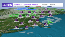
The drier air for most of us will mean quick enough drying to deliver moderate brush fire danger regionwide by afternoon and the breeze gusting to 40 mph at times from the west will knock loose just about every kind of pollen.
Get Boston local news, weather forecasts, lifestyle and entertainment stories to your inbox. Sign up for NBC Boston’s newsletters.
Dry air tends to cool quickly with the loss of sun, so overnight Tuesday night low temperatures will drop to the 30s north and 40s south before a quick rebound to 70 degrees under sunshine Wednesday afternoon.
The next disturbance to cross the New England sky comes Thursday, with showers moving in from west to east Wednesday overnight and lasting through the first half of Thursday before the wind shifts from a moist, ocean flow from the southeast or east to a west wind by afternoon to start the drying process anew.
Thursday’s showers mark the start of returning warmth that will be felt Friday, then really turn on Saturday and Sunday with high temperatures into the 80s, building humidity and a chance of afternoon thunder on both weekend afternoons, but particularly with the approach of a cold front later Sunday or Monday.
Local
In-depth news coverage of the Greater Boston Area.


The speed of the cold front’s passage will determine how high the chance of a renewed shower Monday is, but right now we’re thinking Monday starts the arrival of another shot of drier and cooler air for the first half of next week in our exclusive First Alert 10-day forecast.
