
It was another wintry cold start Monday with temperatures near zero degrees north to the low 20s south. This is the last in this series of colder than average mornings.
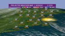
Plenty of sunshine on Monday afternoon, though some clouds are increasing in northern New England, with high temperatures near freezing north and close to 40 degrees south.
It feels really nice because there is light wind.
Get Boston local news, weather forecasts, lifestyle and entertainment stories to your inbox. Sign up for NBC Boston’s newsletters.
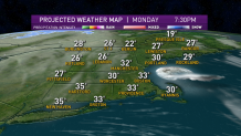
A warm front passing through Ontario and Quebec will generate a few snowflakes near the Canadian border on Monday night and maybe even a sprinkle or a flurry in southern New England by sunrise Tuesday.
Temperatures overnight will not be as cold, with lows in the 20s north and 30s south.
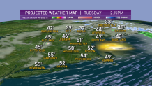
Seasonable high-pressure will work in Tuesday, with a return to sunshine and a high temperature in the 40s to near 50 degrees.
Local
In-depth news coverage of the Greater Boston Area.


We have one more cold night on Tuesday night, with a low temperature in the teens and 20s.
On Wednesday, high pressure in the Gulf of Maine may generate a sea breeze in eastern New England, keeping us in the 40s. Inland areas will warm into the 50s.
High pressure builds to the south of New England on Thursday, bringing all of our wind in from the southwest, resulting in the warmest weather since last year.
High temperatures will be in the low 60s, cooler along south facing shorelines.
A cold front gradually eases in Thursday night and Friday, bringing in clouds and somewhat cooler air to northern New England, where a few showers are possible. The high temperature Friday should still be in the 60s in southern New England, falling back through the 50s and 40s north.
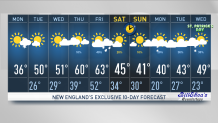
It looks like our transition into the warmer weather and then back into the colder weather late in the week is going to come mostly rain and snow free.
There will be a lot of clouds and gusty winds Thursday and Friday, but little in the way of precipitation. The early call on the weekend is for brighter and mostly seasonable weather as we transition ahead to Daylight Saving Time, as seen in our First Alert 10-Day Forecast.
