
A significant slow moving cold front brings Friday rain and then some Saturday snow.
Early Friday morning, residents of Michigan and Minnesota are waking up to the first snowflakes of the season. Where the leaves haven’t even come off the trees yet, the ground is already turning white. Some of that snow is coming to New England on Saturday morning, depending on where you live.
Get Boston local news, weather forecasts, lifestyle and entertainment stories to your inbox. Sign up for NBC Boston’s newsletters.
The cold front we are tracking Friday has the coldest air since last spring coming in to the Midwest, though the cold will not be as significant here.
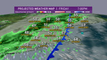
Showers become a steady rain in western New England on Friday afternoon, with temperatures falling into the 50s where it is raining. In eastern New England, we’re close to 70 degrees, with a few breaks of sunshine and intermittent showers. Wind from the south is gusting past 25 miles an hour on the warmer side of the front.
The front comes to the East Coast on Friday night and stalls, with a wave of low pressure riding up from the south. We are tapping some tropical moisture to ring out heavy rain overnight. Rainfall amounts in excess of 2 inches locally are possible.
The freezing level will be coming down overnight, so rain will be changing to snow in the higher elevations of Vermont, northern New Hampshire, and western Maine.
Local
In-depth news coverage of the Greater Boston Area.


The mountains of Vermont just get a thin coating of an inch or two before drier weather by mid-day. But the higher elevations of northern New Hampshire and western Maine could get several inches of snow above 1,500 feet.
You may wake up to rain in Conway, New Hampshire, and then you could drive north to Pinkham Notch into a serious snowfall.
The summits of Mount Washington east to Sugarloaf may get a half a foot of snow above 3,000 feet.
In southern New England, the rain will be heavy at sunrise with a possible thunderstorm. We may have isolated damaging thunderstorm wind gusts, and the downpours will create very deep puddles and tough travel Friday night and early Saturday morning. For that reason we have the First Alert stamp on our forecast overnight.
In the Boston area, we’re expecting 1 to 2 inches of rain with sunshine by noon on Saturday.
Highs Saturday in the 40s north and 50s south with the wind out of the northwest gusting past 30 mph through mid-day.
We all clear out and have a cold night Saturday night with a heavy frost and freeze Sunday morning. Temperatures on Sunday rebound from the 20s and 30s to near 60 degrees for a beautiful day. Next week, another front will stall over New England, with a warming trend and chance of showers each day, as seen in our First Alert 10-day forecast.
