
An exceptionally light mix of snow and freezing rain showers Friday morning created a few isolated slick spots but was representative of the leading edge to milder air that takes over in southern New England for the remainder of the day with plain rain showers.
Temperatures will rise enough in central New England to prohibit much snow accumulation after the morning mixed showers, and northern New England adds up one to three inches over the course of the day with higher amounts in the high terrain.
Get Boston local news, weather forecasts, lifestyle and entertainment stories to your inbox. Sign up for NBC Boston’s newsletters.
The milder air moving into New England Friday on a south breeze comes ahead of the same system that caused a horrific, 80-vehicle crash in Iowa during blizzard conditions on Thursday, with the storm center now charging across the Great Lakes into Canada, dragging warm ahead ahead of its path.
Clearing Friday night precedes a disturbance that could bring a quick, early-morning flurry to the interior Saturday morning before sunshine mixes with fair weather clouds and high temperatures near 40 degrees for a relatively pleasant afternoon.
The next disturbance will be a quick-mover, diving southeast across the Pacific Northwest Friday and clearing the Eastern Seaboard south of New England by Super Bowl kickoff Sunday evening, meaning the highest chance of snow comes to New England when the storm makes its closest path, coincident with another northern disturbance, Sunday mid-morning to Sunday early evening.
From our Friday perspective, it looks like a one to three inch snowfall for many, with three to five inches possible in southeast Massachusetts to Cape Cod, but our exclusive in-house forecast system is still, as of Friday morning, only putting the chance of snow at 65%, meaning there’s still some wiggle room here.
Local
In-depth news coverage of the Greater Boston Area.


The jet stream pattern aloft does not really favor a widespread significant snow, so I’d definitely suggest staying tuned to our First Alert team’s forecasts over the weekend.
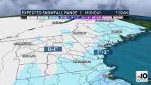
A quiet Monday precedes a likely storm Tuesday – the chance of which is actually, ironically, higher than Sunday’s as of this writing – with accumulating snow for many and a rain/snow line possible near the coast and near southeastern New England.
Thereafter, our exclusive 10-day forecast is colder than normal for the balance of next week with high temperatures in the 20s. Although we have no additional storms in the forecast, each day next week holds a 20 to 30% chance of snow with a busy jet stream nearby all week, so we’ll keep a close eye on each day.
