
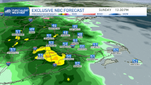
Widespread showers, heavy rainfall, & embedded thunderstorms have been spreading over New England today. The steadier rainfall is coming to an end tonight, pushing out from west to northeast but parts of Maine and NH may still keep showers around in the overnight hours.
Rainfall amounts today have added over 2.5 inches in parts of CT and has even neared 3 inches in spots. Additional amounts are expected through the rest of our Sunday. Reports of small hail, lightning and strong localized wind gusts have affected communities across western New England.
Our weather pattern, however, will remain unsettled through the upcoming week with daily opportunities for isolated to spotty showers.
Get Boston local news, weather forecasts, lifestyle and entertainment stories to your inbox. Sign up for NBC Boston’s newsletters.
In the temperature department, highs along Boston and the coast will stay slightly cooler than normal with the help of the onshore flow. Inland, temperatures may reach the upper 50s a few times, synchronizing with more seasonable numbers.
A cutoff low will meander for much of the week while stuck in southeastern Canada near Quebec.
High pressure system to our northeast and another one to our south will help keep it locked in while several shortwaves coming in will trigger the daily chance for a few showers. Northern New England will likely get the most out of this rain.
Local
In-depth news coverage of the Greater Boston Area.


Be prepared for your day and week ahead. Sign up for our weather newsletter.
