
We saw a beautiful day develop across much of the region Sunday, with highs reaching the low 60s south, the 50s north, with the only exception being far northern Maine where temperatures barely broke into the 40s with stubborn snow and rain showers.
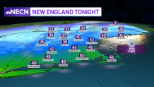
The mild air will remain in place across much of the region Sunday night with the exception of far northern New England where we could see cooler air spilling back into the area behind a cold front. Other than a few stray showers, much of the region should remain dry with some pockets of fog developing during the overnight. Lows will be in the mid 40s to 50s south, 30s north.
Low pressure will track over the Ohio Valley and through northern New England Monday and Monday night, bringing another round of precipitation to the area. Along the Canadian border, we’ll have to watch for wintry conditions, but across central and southern New England, the precipitation will be mostly rain.
Get Boston local news, weather forecasts, lifestyle and entertainment stories to your inbox. Sign up for NBC Boston’s newsletters.
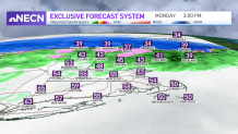
The precipitation arrives in the morning across central and northern areas, it should remain mostly dry south throughout the morning, with the steadiest rain arriving during the afternoon along with an increasing southerly wind. We could also see some heavy pockets of rain along with a few rumbles of thunder.
In terms of snowfall, our exclusive inhouse model is forecasting a general 1 to 3 inches across the higher terrain, with about 2 to 5 inches northern Maine. Highs reach the mid to upper 50s south and 30s and 40s north.
Local
In-depth news coverage of the Greater Boston Area.


Rain exits Monday night with cooler air switching out the mild air. We’ll also be dealing with a gusty northwest wind right through Tuesday afternoon as low pressure exits to our northeast and high pressure builds in from the west.
