
We have a beauty of a day on this Tuesday! Our wind has relaxed and full sunshine continues to spill across the northeast.
Some spots inland reach 60 for highs, while at the coast the temperatures may stay in the upper 40s to low 50s thanks to the afternoon seabreeze.
As the day progresses the clouds also head in from the southwest. A couple sprinkles may be found around the South Coast late in the day, but the heavy rain holds off until Wednesday morning.
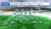
Midweek rain returns for Wednesday into Thursday. The first wave of rain heads through all day Wednesday in southern New England. The rain chance stops abruptly across southern Vermont, New Hampshire, and Maine. Northern New England remains dry.
Get Boston local news, weather forecasts, lifestyle and entertainment stories to your inbox. Sign up for NBC Boston’s newsletters.
Another wave of low pressure moves through all of New England Thursday into Friday.
Late Thursday, we may see a couple thunderstorms around. High terrain in northern New England will see a wintry mix and light snow to then rain, and heavy rain for everywhere else south. Highs will be cooler, in the 40s.
Local
In-depth news coverage of the Greater Boston Area.


After this heavy rain and around 1 to 2 inches of rainfall accumulation, our temperatures warm up a bit late Friday to the 60s. While the heaviest rain moves out in the morning, there may be some instability showers in the afternoon.
More highs around 60 degrees are anticipated both days this weekend but it won’t be completely dry. A cool pool of air aloft will keep daytime pop up showers around from time to time, mainly Saturday.
Next week, our forecast has the potential for 70 degrees as a large warm up moves in. At the coast and in Boston we may stay just shy of the 70 degree mark thanks to a seabreeze. Stay tuned!
