We made it to the weekend! Our temperatures Saturday afternoon set highs in the mid-80s and our humidity has increased just a bit more compared to Friday. Still with bearable humidity, our clouds increase and cover much of the region bringing only a few isolated/light showers.
Our temperatures won’t drop too much Saturday night with humidity increasing and we’ll see lows in the upper 60s to mid-50s. Some fog will develop across the South Shore, but it’s the coastal communities who will enjoy the coolest temperatures.
We’ll enjoy a mostly sunny Sunday with more clouds in the afternoon allowing for a few developing showers. The activity will remain isolated and not affect everyone. The chance for showers is near 30% Sunday; a few of these might bring brief thunder, but they’ll be short lived and not widespread. Temperatures will be warmer, though, and our humidity will reach dew points in the upper 60s, which will be somewhat muggy for many jogging or working outdoors -- especially on Monday morning.
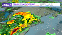
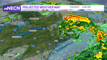
Although our weekend remains mostly dry, rain chances increase on Monday with up to an inch of rain possible across western New England. This brings a relief to our worsening drought, so we’ll take what we can. The highest chance for showers will take place in the mid to late afternoon and last through early Tuesday.
Get Boston local news, weather forecasts, lifestyle and entertainment stories to your inbox. Sign up for NBC Boston’s newsletters.
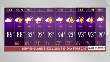
A hot spell is set for the 10-day forecast when we step out of the early week showers and enter a humid and hot stretch. We’ll see highs in the 90s for more than 5 days, which could potentially become our next heat wave.
Plan ahead and start making preparations; consider you’ll be safer using the air conditioner and make accommodations for elderly family members and toddlers who are the most vulnerable.