
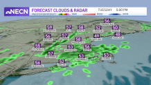
We have a mild day even with all the clouds around. Highs reach the 50s and 60s Tuesday as a cold front approaches and a low pressure center passes over southern New England. We just have a light breeze, but it is enough to give us another day with an elevated wildfire risk until the showers move in.
The showers slowly sink southward Tuesday afternoon and evening, reaching Boston around the evening drive home. It's not a total wash for this evening, but some after-school sports practices may be postponed or canceled.
As the low pressure system settles around the Gulf of Maine and Nova Scotia over the next few days, we continue to see clouds, cool temperatures and some shower chances across eastern New England.
Get Boston local news, weather forecasts, lifestyle and entertainment stories to your inbox. Sign up for NBC Boston’s newsletters.
Thursday through Friday morning, the far North Country will see snow in higher terrain, and also for the crown of Maine. A couple inches are possible in Vermont and New Hampshire, to around half a foot in northern Maine.
Also, as this storm stalls, our wind increases. By Wednesday, winds will be 30 to 40 mph from the northwest. And the gusty northwest wind continues through Thursday and Friday. High temperatures will stay in the 50s and low 50s for this timeframe, with lows in the 30s.
As this storm finally heads out by the weekend, we see our temperatures rebound to the mid 50s on Saturday with fewer clouds from west to east. Sunday we'll be back in the 60s, and these warmer temperatures remain for next week.
