
We made it to meteorological spring! March 1 is the date meteorologists and climatologists use to start spring data.
Astronomical spring, or vernal equinox -- which is based on the earth’s orbit around the sun -- begins on March 20. A few other milestones this month: we turn clocks ahead one hour on March 13, and Boston gains 1 hour and 26 minutes of daylight!
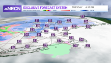
Tuesday morning it felt like winter again, as lows dropped to below zero north and into the single digits and teens south. Our temperatures warm up just a touch as a gusty south wind carries in milder air. Highs will reach the 30s north and low 40s to the south.
The clouds will be thick all afternoon as a clipper system passes to our north. This brings in scattered snow showers in the North Country all day and night. Light accumulation is likely, with coatings to 3 inches of snow across Vermont, New Hampshire and Maine.
Get Boston local news, weather forecasts, lifestyle and entertainment stories to your inbox. Sign up for NBC Boston’s newsletters.
Southern New England will see an interior light wintry mix, so a few rain showers or sprinkles move through late Tuesday and Tuesday night. Lows stay just above freezing south and around 32 north, so watch for some icy spots.
Wednesday brings us a brief break in systems, as we see sun and highs in the mid 40s south. Another clipper brings in light snow by nighttime and we may see scattered coatings in the greater Boston area and interior Massachusetts, to 1 to 2 inches in northern New England through Thursday morning.
Local
In-depth news coverage of the Greater Boston Area.


After that, on Thursday and Friday we have sun and cooler temps in the upper 30s Thursday to low 30s Friday.
This weekend we’re watching a system that lifts northeast across northwestern New England. This means we start with a light wintry mix Saturday night, then change to scattered rain even in northern New England by Sunday.
Milder temperatures are expected to stick around as we start next week.
