Although the focus was on the Patriots for the weekend, the rain had a few tricks up its sleeve, too. What seemed like a mostly dry forecast quickly turned on us in the afternoon Sunday -- more reason not to trust timing and intensity with this setup.
We’re still forecasting a washout Monday, but there may be lulls from time to time.
Also, our guidance isn’t going overboard with anything intense, but there seems to be reason for some heavier bursts of rain later Monday night.
Get Boston local news, weather forecasts, lifestyle and entertainment stories to your inbox. Sign up for NBC Boston’s newsletters.
Again this is more pattern recognition than it is simply following the weather models verbatim.
Rainfall amounts will come in between 1-2 inches with this round of rain, so this is a solid soaking.
The other screaming message is sharply cooler temps. We have a couple of cellar-dwellers coming as highs barely near 60 through Tuesday.
We can trust them to forecast the end of the storm, however. I’m seeing the drying moving in by midweek with a nice bump in the temps.
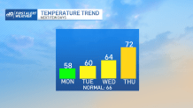
This deep into fall, it’s a treat to see the highs nudge 70, but it seems like we’re in for a decent stretch going into the weekend.
With a strengthening high pressure system to our north, the temps will cool into the weekend, but it also could stave off the rain we were worried about for Sunday. More on that later, however.
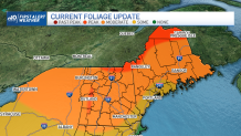
Foliage seems to be coming on strong thanks to the recent cool snap. While the obviously shorter days turn the leaves, the cool nights and semi-mild days help accelerate and brighten the color. Currently nearing peak in far Northern New England in the coming days.