
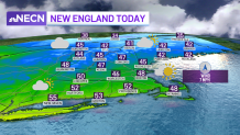
We had widespread frost and a hard freeze for most of New England on Wednesday morning. Temperatures fell to the teens and 20s in almost all weather stations overnight, the exception being Cape Cod and Boston, with lows in the mid 30s.
We rebound nicely with highs in the 40s to near 50 again on Wednesday afternoon. Clouds continue to increase as a warm front heads toward New England. This means our temperatures slowly increase Wednesday evening, with many areas reaching their highs.
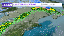
Scattered snow showers are likely to hang around far northern New England all day long, changing to a mix and some ice as temperatures rise. The precipitation mix changes to rain near the Canadian border by Thursday morning and the rain lifts north during the day.
Get Boston local news, weather forecasts, lifestyle and entertainment stories to your inbox. Sign up for NBC Boston’s newsletters.
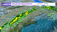
A surge of warm and more humid air heads in as the warm front is in Canada and the wind gusts from the southwest. Highs soar to the 50s north and 60s to the low 70s south. It will feel like a breezy and warm spring day.
The cold front holds off bringing in rain until late evening northwest, and until overnight for Boston. The line of rain moves through all night, ending late morning Friday from west to east. Another boundary sweeps through Friday afternoon and will trigger scattered snow showers in higher terrain as temperatures crash to the 30s and 40s for highs.
On Friday morning, we have a lunar eclipse taking place. However, we don’t have a great chance of seeing it since the rain and clouds will be around for the predawn hours.
Local
In-depth news coverage of the Greater Boston Area.


At least our travel forecast looks better in the northeast this weekend. Sunshine and dry weather takes over both days, with highs in the 30s north and 40s south.
A storm system is brewing for Sunday night -- Monday into Tuesday. This looks like a low pressure system that passes to our north and swings in another cold front, with lingering snow showers in higher terrain Tuesday.
Stay tuned to the latest forecast updates on this storm and how it will impact travel prior to Thanksgiving.
