Snow and a wintry continue to roll through in what constitutes the lion’s share of our accumulation from this storm. Already to the south, the changeover line is marching north, and as temperatures start dropping we will see a refreeze and icy conditions in some areas.
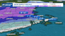
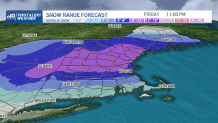
How much snow will we get in Massachusetts?
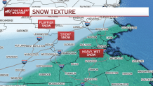
Amounts will be least across southeast Massachusetts, the Cape and the Islands. Elsewhere, we’ll see the mix gradually work in towards mid-morning at the latest. The easterly wind along the coast will also bring in the “milder” air at the same time. This means the snow on the ground will become wetter and heavier and roads will become a little bit better by noon.
Get Boston local news, weather forecasts, lifestyle and entertainment stories to your inbox. Sign up for NBC Boston’s newsletters.
When will the most intense snow come through?
Here's a closer look at the timing of the storm, and which areas will be hardest hit:
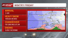
When is the snow going to stop?
Sleet will barge onto the scene through the early part of the afternoon. As the storm begins to move away Friday afternoon, colder air will swing back in from northern New England. This will cause temperatures to plummet late day and any spots that rise above freezing will be prone to a refreeze. This will create new slippery spots on untreated surfaces, and because of that, the evening drive will be challenging (better than the morning drive, but still not ideal).
More snow Friday night?
The return of the colder air (in all levels of the atmosphere) also means a return to snow for all locations this evening. There could be an additional 1 to 2 inches just with “leftovers” this evening. Snow should taper off slowly as the night progresses, likely not ending on the Cape until 10 to 11 p.m.
A cold start to the weekend is expected. We’ll barely make it to freezing in most locations. Sunday features a bit of a moderation, with more cold returning by Monday.
We’re here to guide you through the storm. Stay safe and enjoy the sun this weekend.