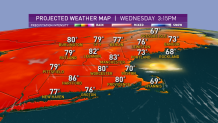
We have another day of overachieving high temperatures in the low 80s Tuesday, with just a few showers or thunderstorms in the evening, exiting southeast Massachusetts, including Cape Cod, by about 10 p.m.
The rather low humidity air has been allowing temperatures to drop noticeably at night, and for those without pollen allergies this has meant great nights to open windows and cool the house. Tuesday night will be no exception. With a lighter prevailing wind Wednesday, sea breezes will develop a bit earlier and be a bit stronger, meaning a greater difference in afternoon temperatures from 80s inland to 70s along the coast.
On the water, our mariners and boaters continue to enjoy a great stretch of weather, with seas no greater than one to two feet in near-shore waters – closer to three feet Tuesday offshore – on any given day this week.
After warmth peaks Wednesday in warmth on the southern side of the jet stream winds aloft – the jet stream is the fast river of air, high in the sky, that steers disturbances and separates cool air to the north from warm to the south – the jet stream will very slowly start to sag southward again, meaning the pathway aloft for disturbances slowly nears New England again.
Get Boston local news, weather forecasts, lifestyle and entertainment stories to your inbox. Sign up for NBC Boston’s newsletters.

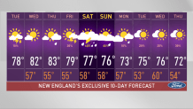
Thursday sees a chance of late day showers or thunder mostly confined to northern and western New England, and while Friday’s chance expands a bit across New England, any showers or thunder are still expected to be limited and mostly late day.
Things change on Saturday as a stronger jet stream disturbance moves over New England and pulls a slow-moving cold front into the region, raising the risk for showers and thunder. They may not be confined to the afternoon – the timing and intensity is something we’ll continue to nail down this week.
By Sunday, the slow-moving front may actually stall and turn around, allowing for some warming and a more scattered nature to any showers and thunder, with the focus shifting back toward afternoon and the bulk of the area expected to remain milder than normal through the end of the 10-day forecast.


