
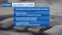
We continue with a First Alert for Saturday as a major coastal storm is more likely to impact New England. Keep in mind that the track may shift several times with each model run between now and Saturday, but this storm is so large it will be hard for us to get a miss. Here are some early thoughts on impacts, which are dependent on the storm track.
Timing & snowfall totals:
Friday night into all day Saturday is our timeframe, with the worst of the storm Saturday morning through afternoon. This timing is not set in stone, but that’s what it looks like now.
Get Boston local news, weather forecasts, lifestyle and entertainment stories to your inbox. Sign up for NBC Boston’s newsletters.
A cold front from the north slides in Friday late day and will bring in some snow showers, but the main storm offshore to our south is only just beginning to strengthen. s the storm heads northeast just off the coast, it may take a path over the “benchmark” 40N, 70W. This would give us a classic nor’easter, burying Boston in a foot or more of snow and blasting the coast, with blizzard conditions also likely for some. Our guidance has been consistent with around a foot or two across eastern New England and we continue to see this signal.
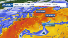
Damaging winds:
Saturday after midnight the winds ramp up from the northeast. Forty to 50 mph gusts are likely at the coast, and 30 to 40 mph inland. Then as the low pressure system deepens and heads toward the benchmark, we expect 60 to 70 mph gusts, to 70 to 80 mph winds offshore. This will bring damage and outages across the coast, more scattered inland. The wind continues to stay strong all day.
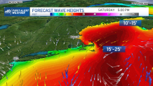
Coastal flooding:
Tides are increasing astronomically through the weekend. We expect at least minor to moderate coastal flooding with a 1 to 3 foot storm surge for the Saturday morning and Saturday evening high tides (Boston 8 a.m. and 9 p.m.; flood stage is 12.5 feet). Waves of 15 to 25 feet will be offshore, building through the morning and afternoon.
Wednesday and Thursday are nice and quiet for any storm preparations. Highs will be in the 20s, with lots of sunshine and a light northwest breeze. Wednesday night’s lows drop to the single digits south and below zero again to the north, but with little wind to add to the chill.
Local
In-depth news coverage of the Greater Boston Area.


Thursday brings us sunshine and highs in the 20s again. Friday, we start off cloudy with highs in the mid 30s.
Snow showers head in Friday night, then the big storm hits Saturday. For Sunday, we have highs in the mid 20s and sunshine -- a good day for storm cleanup. Next week we remain quiet through at least midweek and temperatures increase a bit to the 30s and then mid-40s by Wednesday.
Be prepared for your day and week ahead. Sign up for our weather newsletter.
