
A storm system will be moving into the New England area overnight. Southerly winds are warming us up, but the precipitation is quickly moving in.
West of Worcester you might be doing some slipping and sliding overnight. The warm up will be a bit delayed in New Hampshire, Maine, central Massachusetts and northwestern Connecticut. Even in these locations, temperatures will warm above freezing by the morning commute.
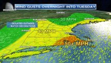
Winds will increase through the night. We’re expecting the strongest wind gusts throughout southeastern Massachusetts — where 50+ mph gusts will be common. 40 mph gusts seem reasonable throughout the remainder of New England with the current weather set up. If you have early morning trash pickup, keep an eye on the trash cans — they could end up in your neighbor’s yard. Another thing to watch will be your inflatable Christmas decorations.
Those strong, southwest winds will warm us into the 50s during the day. Most of us will catch a glimpse of the sun before sunset too — it should be a nice day. 50s aren’t new to New England during late December — 61° happens to the record high temperature for the day.
We catch a break from the active weather on Wednesday. The day will feature mostly sunny skies and temperatures in the upper 30s and low 40s — typical for this time of year.
Thursday — all eyes will be on a developing storm system. It will bring us a significant amount of precipitation and some strong winds. It’s too early to determine what TYPE of precipitation we’ll see, but confidence is high enough for us to say — a quick burst of snow is likely during the onset. The potential is there for significant accumulations away from the coast.
