A cool and blustery afternoon with wind chills in the low 50s to upper 40s and an even colder night ahead.
Frost advisories and freeze warnings stretch from the Berkshires into northern New England. Cheshire County will have a frost advisory while Windham County in Vermont will see temperatures feeling in the 20s under a freeze warning through early Monday. This may kill crops or other sensitive vegetation and possibly damage unprotected outdoor plumbing.
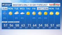
We jumped into October and we jumped into near winter conditions. The exclusive 10-day forecast is showing temperatures dipping into the 30s next weekend and possibly bringing a taste of winter conditions to Mt. Washington or high elevation areas.
For now, though, temperatures will rise to mid and upper 50s but will feel more like the lower end of the 50s. Winds will gust as high as 50 mph far southeast and over 30 mph as far up as Boston. This keeps rough seas running up from 7-11 feet high and gale warnings in effect along all of the New England coast. While Ian’s remnants meander offshore, moisture will bring the chance for sprinkles south and mostly cloudy skies through much of the day.
Get Boston local news, weather forecasts, lifestyle and entertainment stories to your inbox. Sign up for NBC Boston’s newsletters.
Temperatures remain below average through Tuesday with highs in the mid to upper 50s. With Ian’s remnants meandering south through then, the chance of showers increases Tuesday through Wednesday and remains mainly across central and southern New England.
Northern New England, however, will watch for lows dipping into the 30s next weekend. This, if moisture remains, may bring the chance for the first flurries of the season in the highest elevations far up north. In the south, temperatures will dip again into the 50s with lows down to the 30s; frost advisories are likely.