
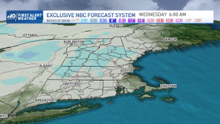
Although the week has started with a familiar feeling of exceptionally mild air for this time of the year, New England is poised to turn a corner into cooler temperatures and, as a result, a better chance of putting snow on the ground in the days ahead. For one more day, temperatures rise some 15-20 degrees above normal for the date, even with lots of clouds, reaching 55 to 60 degrees in Southern New England and around 50° even in Ski Country. Although a few mixed rain and snow showers are possible Monday afternoon in Northern New England and a sprinkle or two may pop up farther south as a cold front cuts from northwest to southeast across New England, the better chance of scattered snow and rain showers comes overnight Monday night near the South Coast and in far Southern New England, when an energetic disturbance bisects the frontal boundary. As the front slows near New England’s South Coast Tuesday and Tuesday night, each weak disturbance to ripple through the atmosphere aloft will prompt snow and rain showers, but with temperatures marginal for wet snow versus rain, accumulations will be scant until perhaps late Tuesday into Tuesday night, when temperatures cool more and a coating to an inch of snow is expected for many in Southern New England on grassy surfaces, with a fresh one to two inches in the higher terrain and in Northern New England. It would appear this is only the first shot of a few disturbances to set sights on New England. After a break Wednesday, the next disturbance will prompt storm development through the Great Lakes Wednesday and into New England Thursday, likely to push a Wednesday night burst of snow from southwest to northeast across New England with a broad coating to 4” of snow in Southern New England, South Coast to Southern NH, respectively, and amounts of 6” to 12” in Ski Country. The lower amounts in Southern New England are expected because of warmth coming quickly on the heels of the snow – likely sufficient to change snow to a wintry mix, then rain, in Southern New England Thursday after a slowed morning commute for which our weather team continues a First Alert. The passage of this storm opens the door to colder air with a strong dome of high pressure building across the Northeast and chilly air with subfreezing high temperatures Saturday. Some snow may fall Saturday night into Sunday as warmth races back in on the heels of this cold air, but it remains to be seen how organized that snow will be. It does appear as though an active pattern of frequent disturbances – and corresponding elevated chances for snow and rain – will continue through at least the first week of March if not the first half of the month.
Get Boston local news, weather forecasts, lifestyle and entertainment stories to your inbox. Sign up for NBC Boston’s newsletters.
