A coastal system which brought a mixed bag of precipitation to the region will continue to pull away from New England Tuesday afternoon and evening.
Clouds will slowly clear from west to east across southern New England Tuesday afternoon, but we’ll still be dealing with a few rain showers and sprinkles along with patchy fog over eastern areas through the mid-afternoon/early evening hours.
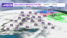
Across the north, snow will slowly come to end across northern New Hampshire and Maine by Tuesday evening where we could see several inches more.
Get Boston local news, weather forecasts, lifestyle and entertainment stories to your inbox. Sign up for NBC Boston’s newsletters.
Please take it slowly if traveling across those areas. Highs reach the upper 30s to low 40s south, and 30s north.
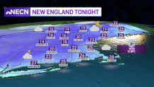
High pressure builds into the region Tuesday night, providing us with some cold temperatures but not the Arctic air we’ve seen in the past, which will be on hiatus for a while thanks to the new pattern we’re in. We will need to watch out for some black ice Tuesday night into Wednesday morning as some of the puddles from today’s rain and snow melt refreezes. Lows dip into the teens north, low to mid 20s.
The sun will be back Wednesday as high pressure remains in control with temperatures close to or just above average for this time of year. It's looking like a fantastic day to hit the slopes, if you can! Highs reach the upper 30s to low 40s south, and 30s north.
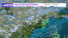
Going forward, the pattern remains quiet, with a weak system moving through Thursday delivering milder temperatures with a few rain showers south, and a mix/rain across the north. Behind that, we’ll see temperatures falling back to seasonable levels Friday, but that will be short lived as we take a run at 50 (south) on Saturday!