
-
Hardy souls across New England dig out after major winter storm
Thousands of hardy souls across New England spent Sunday digging out after a major weekend storm dumped more than two feet of snow in some areas, caused multiple road accidents, downed power lines and left hundreds of thousands across the Northeast in the dark, some perhaps for days. Heavy snowfall also hit upstate and northern New York. Many areas saw...
-
Boston's chill continues, some light snow possible overnight
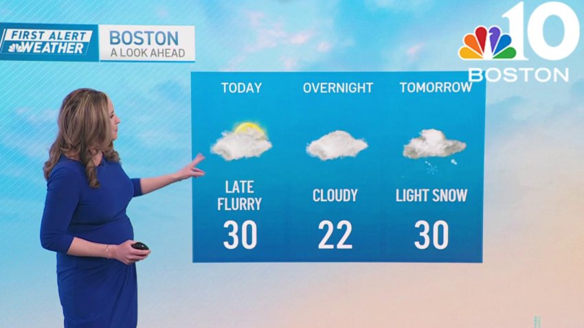
Thursday: Limited sun to clouds, chance PM flurry. Highs near 30.
Overnight Tonight: Cloudy. Lows near 20.
Friday: Light snow. Highs near 30.
Saturday: Mostly cloudy, cold, Outer Cape PM snow shower. Highs around 20.Follow NBC10 Boston on…
Instagram: instagram.com/nbc10boston
TikTok: tiktok.com/@nbc10boston
Facebook: facebook.com/NBC10Boston
X: twitter.com/NBC10Boston -
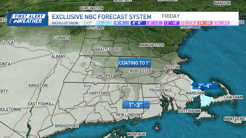
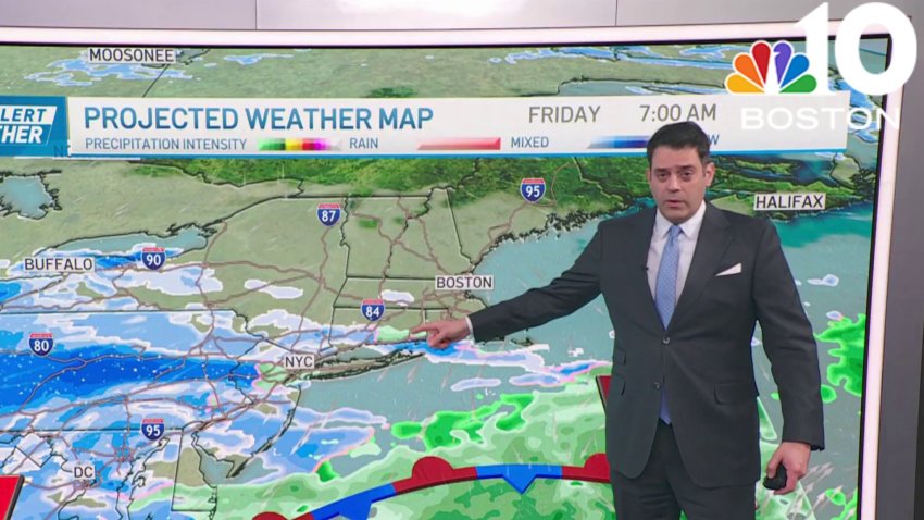
More snow coming Friday, but parts of Boston area will get more
Although New England remains chilly Thursday, the air isn’t quite as dry as it was Wednesday. This allows for quickly increasing clouds that will look like snow is coming most of the day, but at day’s end into evening, only a few flurries will fall as a disturbance aloft passes through the New England sky. Daytime wind chill values...
-
Boston will see limited sun Thursday, with temps near 30
Thursday: Limited sun to clouds, chance PM flurry. Highs near 30.
Overnight Thursday night: Cloudy. Lows near 20.
Friday: Light snow. Highs near 30.
Saturday: Mostly cloudy, cold, Outer Cape PM snow shower. Highs around 20. -
Forecast: A few flakes, cold and quiet through Tuesday
Sunday night: Mainly clear and chilly. Lows in the upper 20s to low 30s
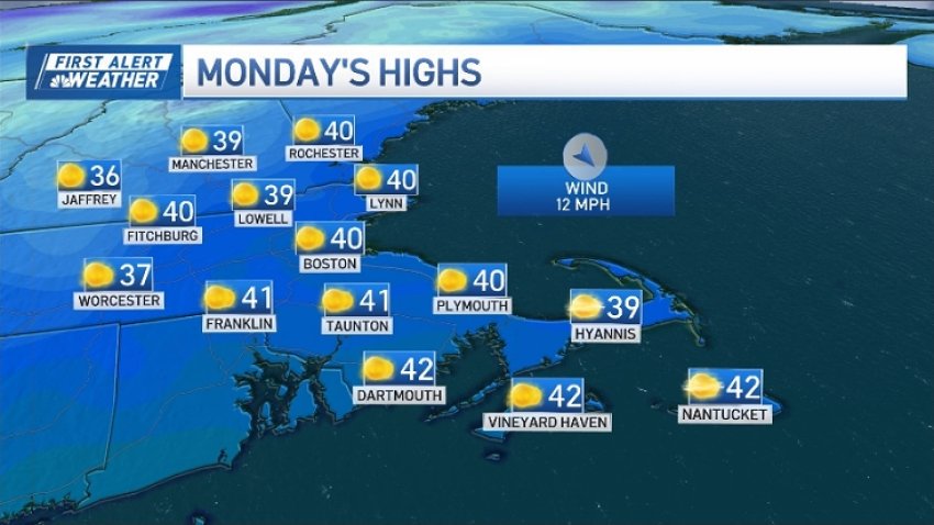
Monday: Sunny and cool. High around 40.
Tuesday: Increasing clouds. High in the mid 40s. -

Forecast: Quiet and cold through Tuesday
Sunday night: Mainly clear and chilly. Lows in the upper 20s to low 30s
Monday: Sunny and cool. High around 40.
Tuesday: Increasing clouds. High in the mid 40s. -
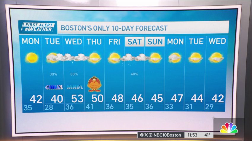
Cold and quiet through Tuesday when next storm systems starts heading our way
It was nice to have sunshine and seasonal temps across the area on Sunday. We will continue with the sunny theme on Monday, but we will also have a drop in afternoon high temperatures. After starting Monday morning on a cold note (20s to around 30), we will only make it back into the low 40s by the afternoon. The…
-

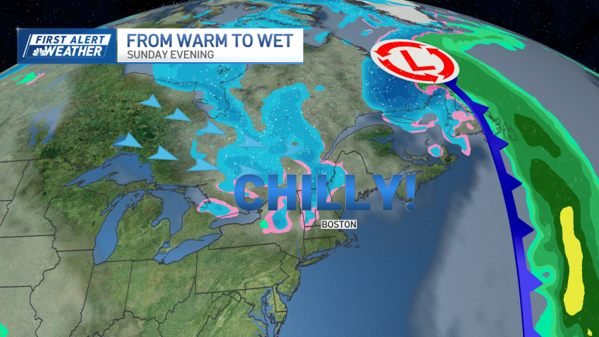
Sunny and breezy Sunday in New England
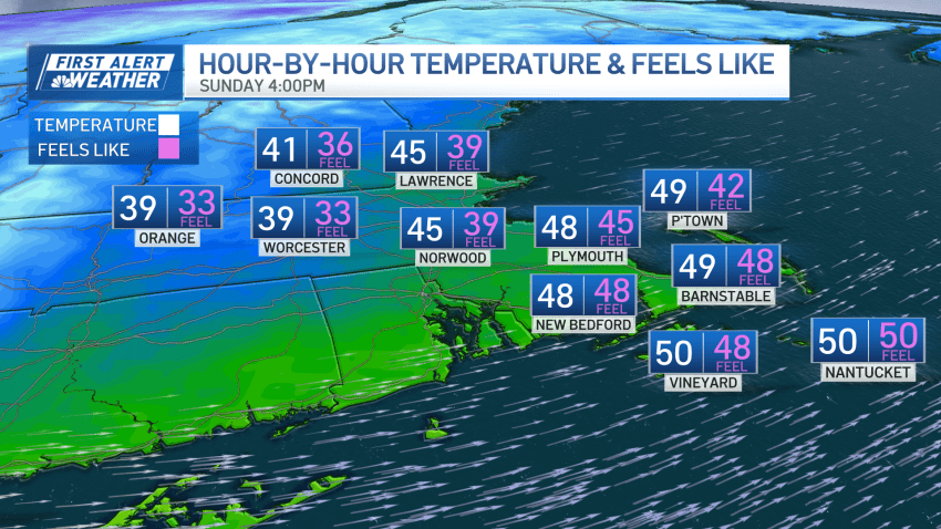
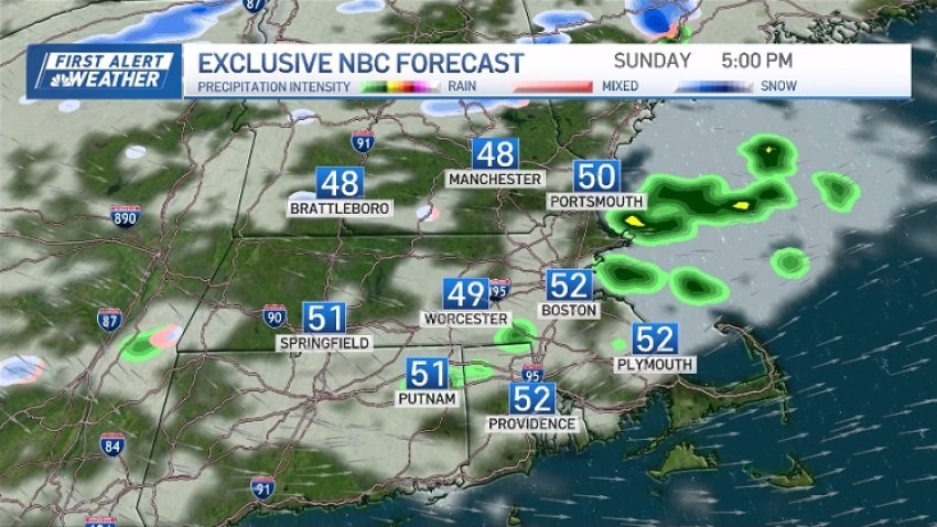
Today: Mostly sunny with a bit of a breeze. High around 50. Tonight: Mainly clear and chilly. Lows in the upper 20s to low 30s Monday: Sunny and cool. High around 40. Tuesday: Increasing clouds. High in the mid 40s.
-
Drier air moves through New England on Sunday
The weather in New England takes a turn as drier air moves in following the passage of a cold front Saturday. Mostly clear skies last night allowed the temperatures to drop into the 30s. Expect a bright and breezy Sunday, although the tail end of an upper-level storm system may bring a few extra clouds and isolated showers to parts…
-
Drier air moves through New England on Sunday
Today: Mostly sunny with a bit of a breeze. High around 50. Monday: Sunny and cool. High around 40.
-
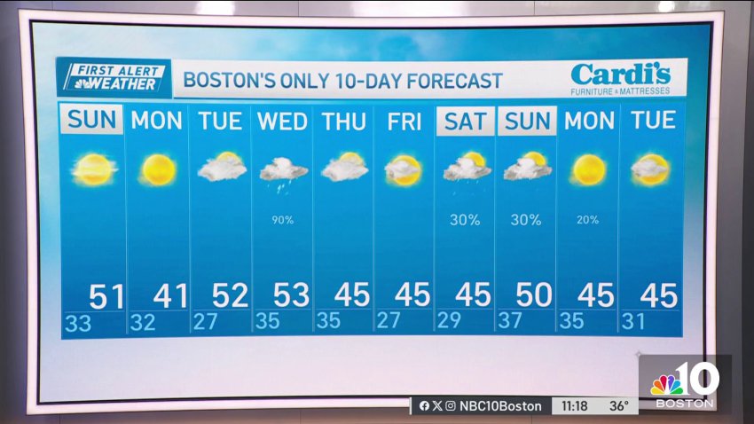
Forecast: Mostly sunny and cool Sunday, Monday
Saturday night: Mainly clear and chilly. Lows in the upper 20s to low 30s
Sunday: Mostly sunny with a bit of a breeze. High around 50.
Monday: Sunny and cool. High around 40. -
Sunny and dry Sunday after cool Saturday night
Thanks to the passage of the cold front earlier Saturday, we’ve got drier air making its way back into New England for the second half of the weekend and the start of Thanksgiving week. For Saturday night, expect a mostly clear sky with temperatures dropping into the upper 20s to low 30s. Sunday will be a dry day with...
-
Cooler Saturday afternoon in New England
Today: AM showers, decreasing clouds and cooler in the afternoon. Temps in the 50s AM, 40s PM Tonight: Mainly clear and chilly. Lows in the upper 20s to low 30s Sunday: Mostly sunny with a bit of a breeze. High around 50. Monday: Sunny and cool. High around 40.
-
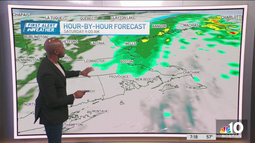
Scattered showers before cooler evening on Saturday
A cold front brushing through this morning will make your Saturday… interesting. The morning will feature scattered showers, not everywhere getting wet at all times, and rain totals will be around 0.25”. Just before noon, we begin a cooling trend. Temperatures start in the upper 50s and will fall to the upper 40s by noon. Wind gusts increase to 25…
-
Mid-day showers lower the temperature on Saturday evening
Saturday: Highs in the upper 50s early AM, dropping temperatures PM reaching 40s. AM-midday showers, ending mid PM. Sunday: Highs around 50, upper 40s west, sunny, blustery, colder wind chill.
-
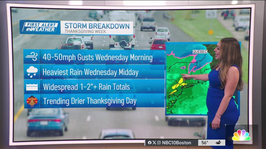
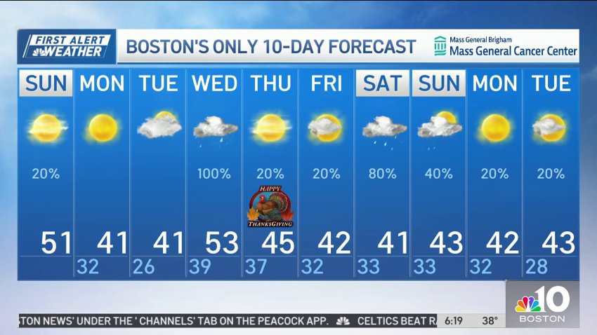
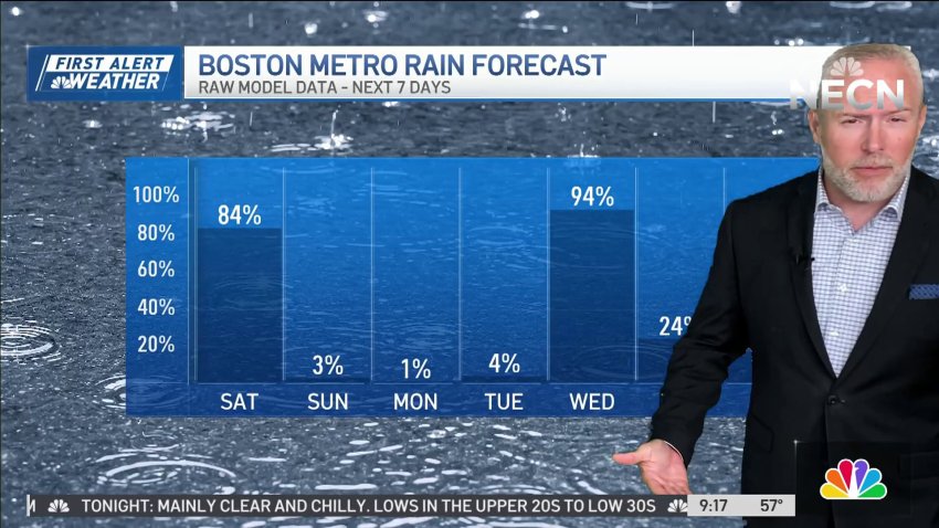
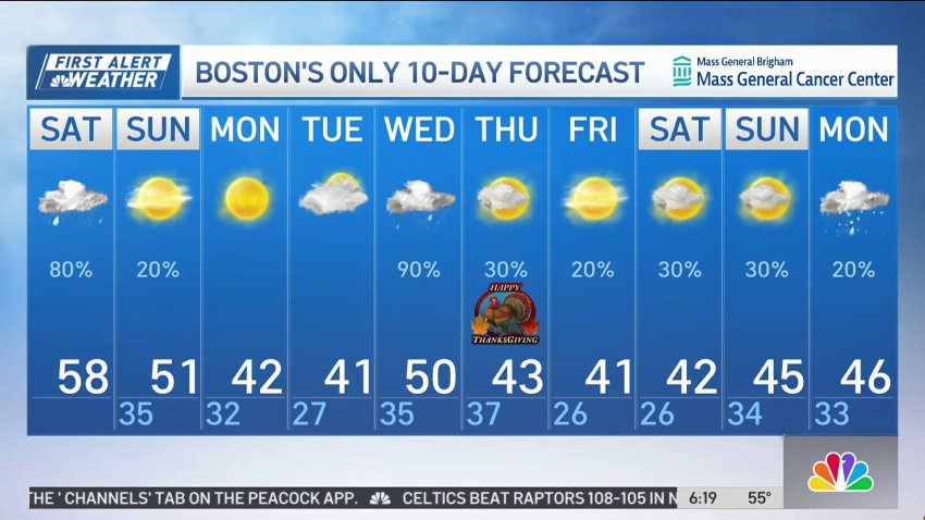
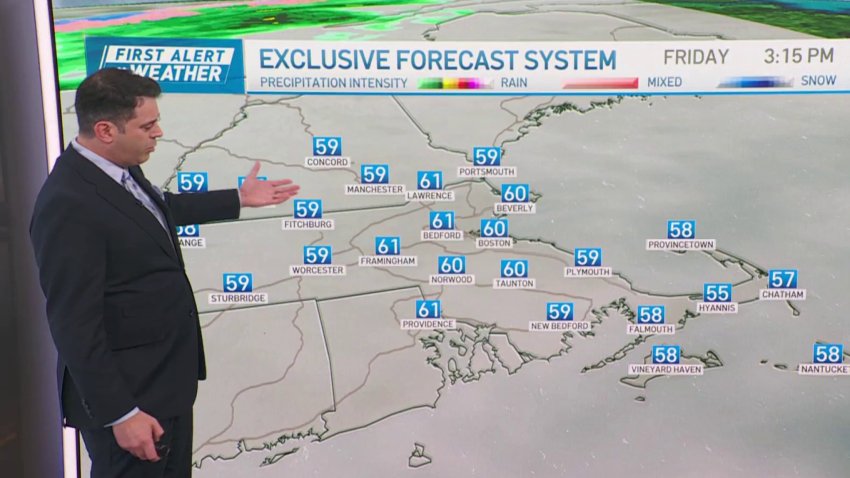
Forecast: Showers Saturday, storm expected Thanksgiving week
Overnight: Lows in the lower 50s, cloudy, light/scattered showers arrive.
Saturday: Highs in the upper 50s early AM, dropping temperatures PM reaching 40s. AM-midday showers, ending mid PM.
Sunday: Highs around 50, upper 40s west, sunny, blustery, colder wind chill. -
Forecast: Light, scattered showers move in overnight
Friday evening: Temperatures in the upper 50s, mostly cloudy.
Overnight: Lows in the lower 50s, cloudy, light/scattered showers arrive.
Saturday: Highs in the upper 50s early AM, dropping temperatures PM reaching 40s. AM-midday showers, ending mid PM.
Sunday: Highs around 50, upper 40s west, sunny, blustery, colder wind chill. -
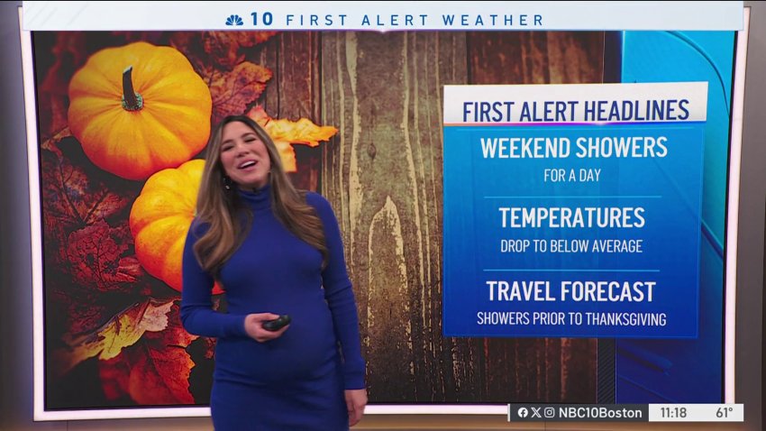
Forecast: Weekend showers, cooler temps
Friday Night: Temperatures in the upper 50s, mostly cloudy. Overnight Friday: Lows in the lower 50s, cloudy, light/scattered showers arrive. Saturday: Highs in the upper 50s early AM, dropping temperatures PM reaching 40s. AM-midday showers, ending mid PM. Sunday: Highs around 50, upper 40s west, sunny, blustery, colder wind chill.
-
Here's when to expect some rain, temperatures to drop
We’re wrapping up the work week with mild air, temperatures reaching the 60s and bright skies. However, a strong cold front is set to approach the region late Friday night, bringing a brief period of showers that will exit the coast by early Saturday afternoon. This transition will be marked by a turn to chilly weather accompanied by a...
-
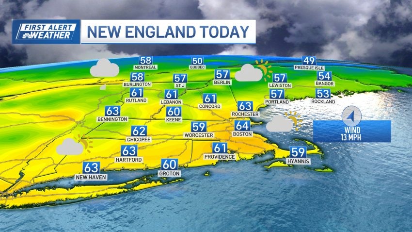
Expect some showers on Saturday
Today: Sun to clouds, breezy PM. Highs 60-65. Overnight Tonight: Scattered showers, mild, patchy fog. Lows in the 50s south, 40s north. Saturday: Mild AM & Midday showers, then partial clearing with a cool wind. Morning highs in the 50s, 40s late. Sunday: Fair, cool breeze, isolated shower. Highs near 50. Monday: Sunny, brisk. Highs in the lower 40s.
Trending
