
-
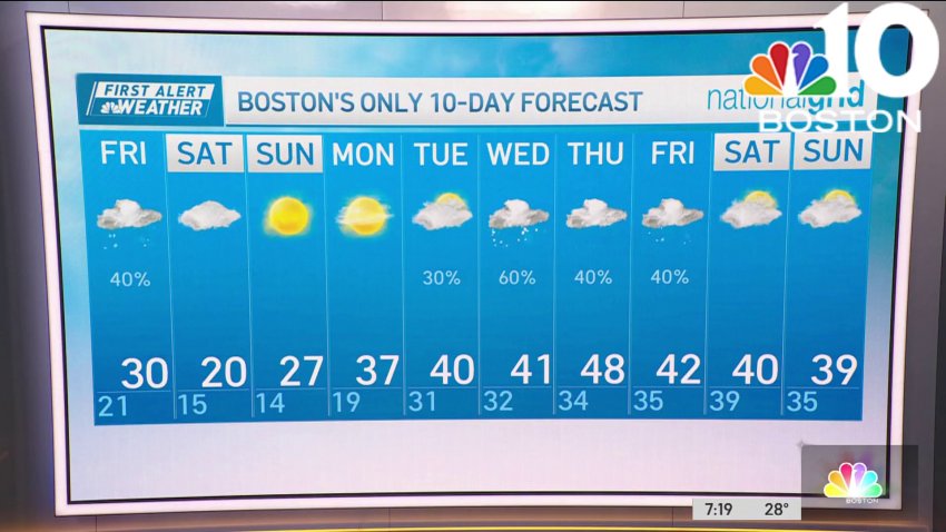
Chilly Saturday on what has been a warmer than usual February
As we enter the final weekend of February, it will feel more like what we’d expect from a month that has the reputation for being one of the coldest months of year. That certainly isn’t so this year! As we look back at the climatology for the month, so far in Boston, you’ll notice that there has yet to...
-
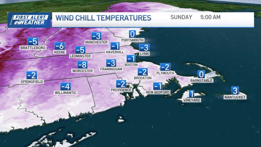
Chilly conditions in New England through the weekend
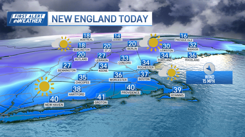
Today: Few AM clouds, afternoon sun, breezy, and cold. Highs in the 30s, windchills in the teens. Tonight Overnight: Mostly clear, breezy, and cold. Lows in the teens, windchills single digits. Sunday: Mostly sunny, less wind. Highs in the upper 30s.
-
Chilly Saturday to kick off the weekend
More cold air has moved into New England this morning. While we didn’t feel its pinch last night, it will muffle any attempts at a warmup today with a gusty northwest wind. Wind chills turn from cold to frigid after sunset. If you’re stepping out this evening, plan it feeling like teens and single digits. We’re still not seeing...
-
Chilly Saturday to kick off the weekend
Today: Few AM clouds, afternoon sun, breezy, and cold. Highs in the 30s, windchills in the teens. Tonight Overnight: Mostly clear, breezy, and cold. Lows in the teens, windchills single digits. Sunday: Mostly sunny, less wind. Highs in the upper 30s.
-
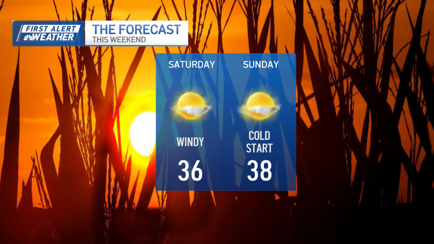
Weather forecast: Sunny, windy and cold
Friday night: Showers end, partial clearing, colder. Lows in the mid 20s. Saturday: Mostly sunny, breezy, and cold. Highs in the 30s, wind chills in the teens. Sunday: Mostly sunny, less wind. Highs in the upper 30s.
-
Weather forecast: Chilly night
Friday night: Showers end, partial clearing, colder. Lows in the mid 20s. Saturday: Mostly sunny, breezy, and cold. Highs in the 30s, wind chills in the teens. Sunday: Mostly sunny, less wind. Highs in the upper 30s.
-
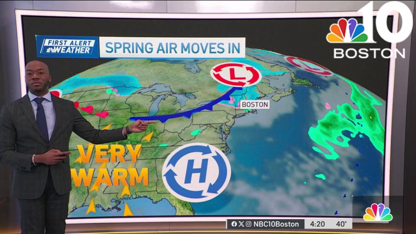
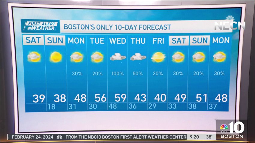
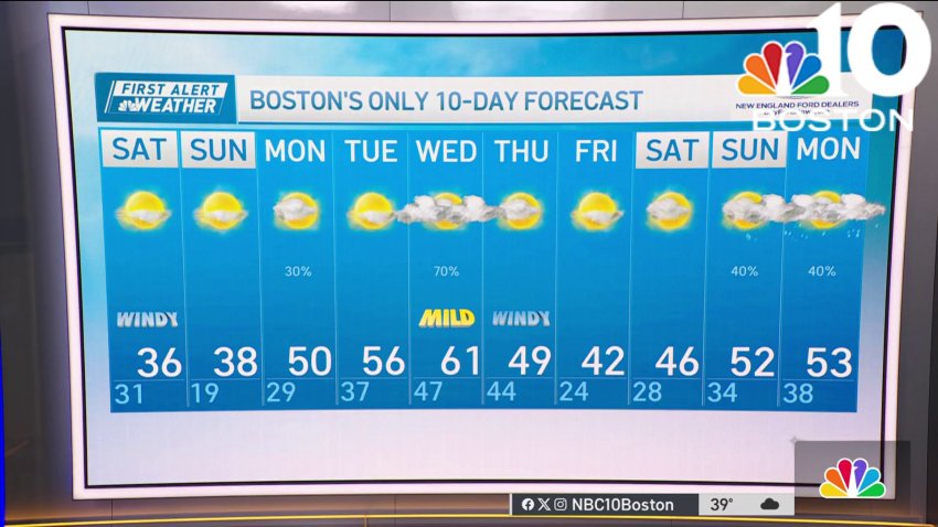
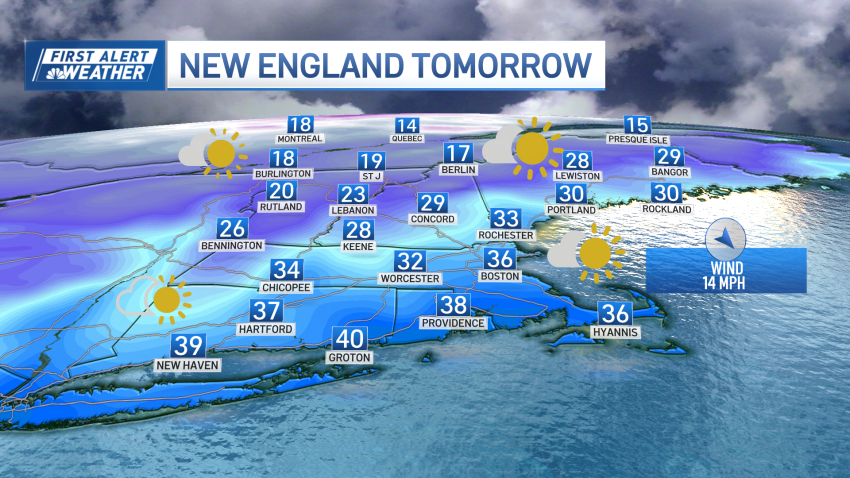
Forecast: Chilly weekend, spring air moves in next week
Overnight: Showers end, partial clearing, colder. Lows in the mid 20s. Saturday: Mostly sunny, breezy, and cold. Highs in the 30s, windchills in the teens. Sunday: Mostly sunny, less wind. Highs in the upper 30s.
Follow NBC10 Boston on…
Instagram: instagram.com/nbc10boston
TikTok: tiktok.com/@nbc10boston
Facebook: facebook.com/NBC10Boston
X: twitter.com/NBC10Boston -
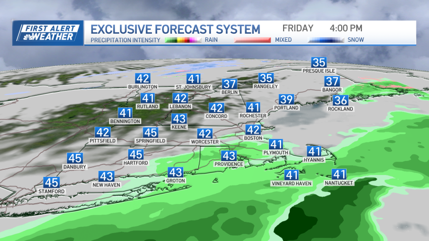
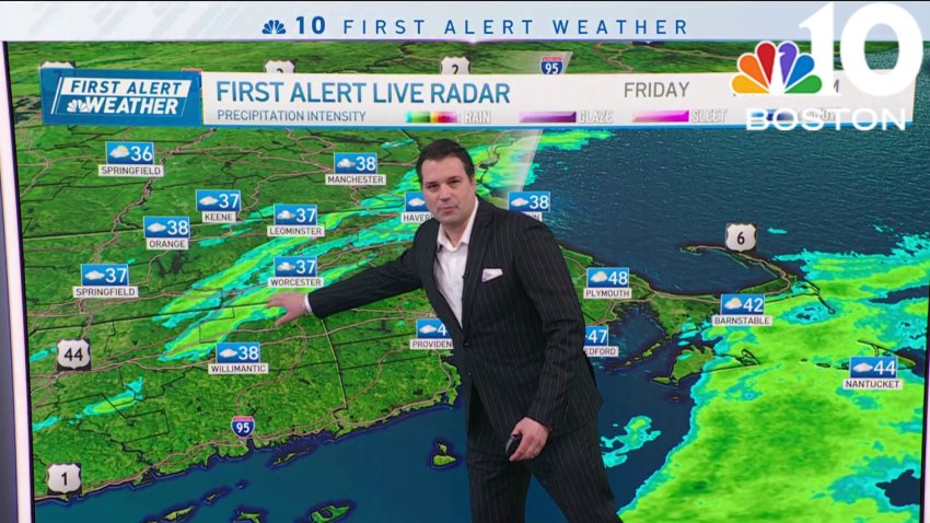
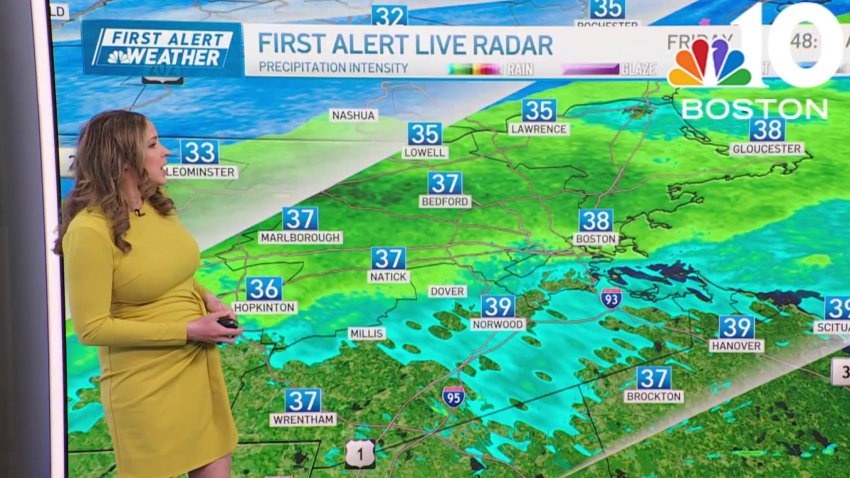
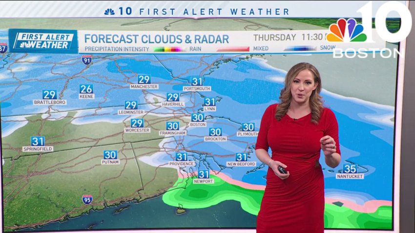
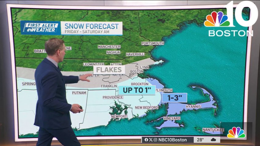
Rain showers continue Friday, cold air arrives for the weekend
A weak system will slide through New England Friday afternoon keeping us unsettled through early Friday night. Rain showers will continue through Friday evening across eastern areas before shutting down early, they’ll be a bit more persistent across southeastern Massachusetts and the Cape due as another area of low pressure develops south of New England and spins more moisture...
-
Weather forecast: Rain persists Friday afternoon
Friday: Periodic rain, mix in higher terrain, tapering to showers by evening. Mountain light snow. Highs in the 40s, 30s north.
Overnight Friday night: Showers end early, partly cloudy. Lows in the mid 20s.
Saturday: Fair and cool. Highs in the 30s.
Sunday: Sunny. Highs in the upper 30s.i -
Cold weekend but a warm up is on the way next week
A weak system will slide through New England Friday providing rain south and a mixture of rain and snow north. Expect to see precipitation shut down from west to east Friday afternoon with eastern portions of New England holding on to rain showers through this evening, especially across the Cape and Islands where rain may be a bit more...
-
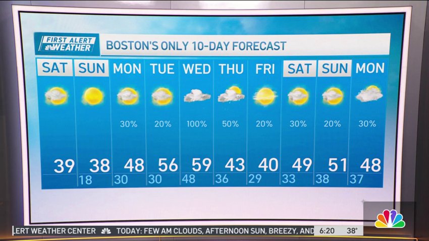
Boston sees rain, with temps in the high 30s Friday morning
Friday: Periodic rain, mix in higher terrain, tapering to showers by evening. Mountain light snow. Highs in the 40s, 30s north.
Overnight Friday night: Showers end early, partly cloudy. Lows in the mid 20s.
Saturday: Fair and cool. Highs in the 30s.
Sunday: Sunny. Highs in the upper 30s. -
Weather forecast: Clear and chilly night
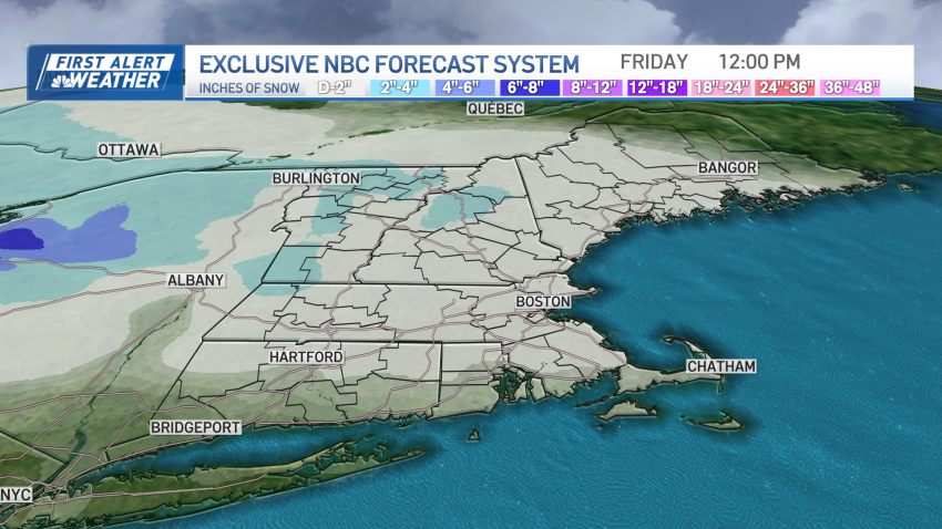
Wednesday night: Cold wind, clear sky. Lows around 20. Thursday: Morning sun, afternoon clouds, evening and night snow, a coating to 2″. Highs 35-40. Friday: Blustery, fair, chance flurry/sprinkle. Highs 35-40.
-
Forecast: Storm leaves behind chilly air in Boston
Overnight Wednesday night: Cold wind, clear sky. Lows around 20.
Thursday: AM sun, PM clouds, evening and night snow, a coating to 2″. Highs 35-40. Friday: Blustery, fair, chance flurry/sprinkle. Highs 35-40. -
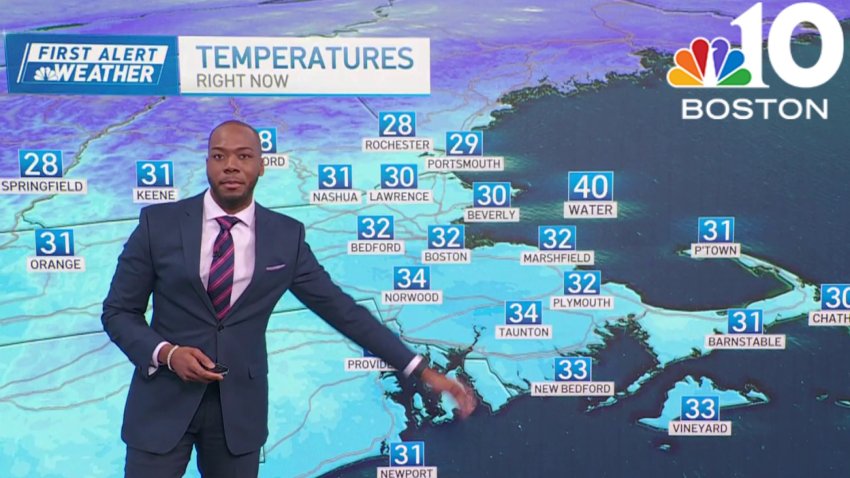
It's a cold Valentine's Day, with high temps around 30
Wednesday: Blustery and bright. Highs around 30, wind chill 20.
Overnight Wednesday night: Cold wind, clear sky. Lows around 20.
Thursday: AM sun, PM clouds, evening and night snow, a coating to 2″. Highs 35-40.
Friday: Blustery, fair, chance flurry/sprinkle. Highs 35-40. -
Blustery midweek conditions, with light snow Thursday evening
As Tuesday’s storm departs through the Canadian Maritimes after dropping a rare 9 inches of snow at Chilmark, on Martha’s Vineyard, the broad and far-reaching counterclockwise flow of air around the storm has ushered a feisty northwest wind into New England, transporting a fresh shot of chilly, dry air from Canada. The upside to this air is the dry...
-
Blustery and bright in Boston Wednesday
Wednesday: Blustery and bright. Highs around 30, wind chill 20.
Overnight Wednesday night: Cold wind, clear sky. Lows around 20.
Thursday: AM sun, PM clouds, evening and night snow, a coating to 2″. Highs 35-40.
Friday: Blustery, fair, chance flurry/sprinkle. Highs 35-40. -
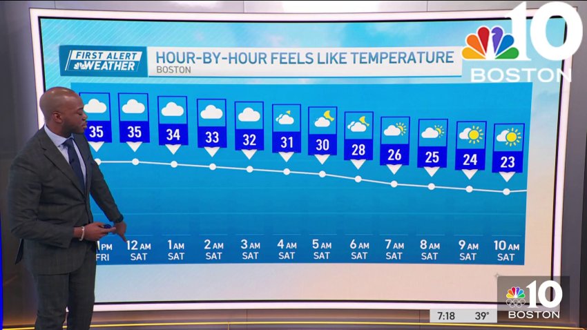
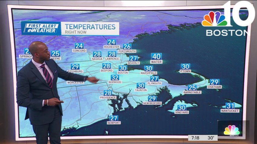
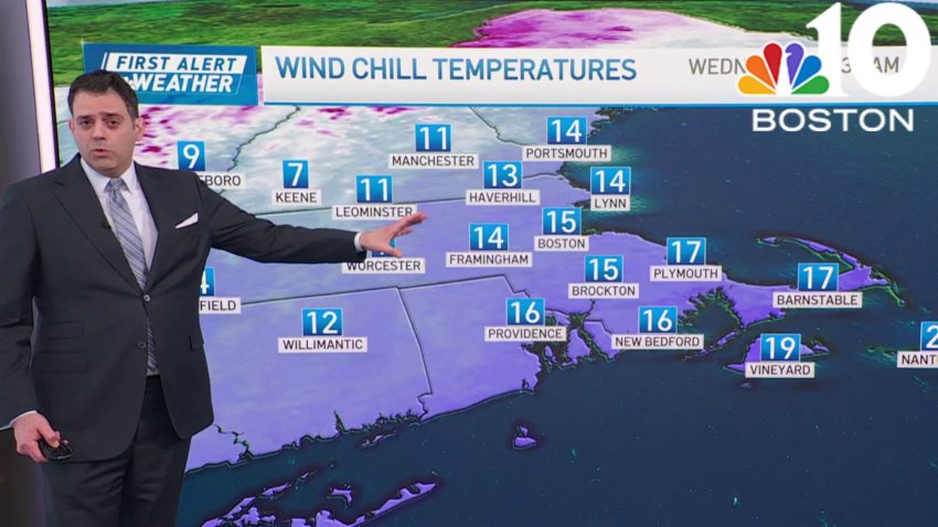
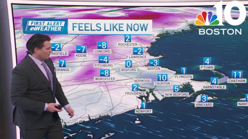
Wind chills in the single digits in New England during the weekend
Your Saturday morning begins with wind chills in the single digits above and below freezing. A frigid weekend is ahead. For Saturday, temperatures will stay 10-20 degrees below normal, with wind gusts near and above 20 mph. Cloud cover is expected due to a shortwave, limiting sunshine. Highs will be in the teens to low 20s, and it will be...
-
Wind chill at single digits across New England on Saturday
Today: Lots of clouds, breezy, very cold. Highs near 20, wind chill single digits....
...Overnight Tonight: Decreasing clouds, breezy, and frigid. Lows around 10, wind chill below 0....
...Sunday: Mostly sunny, cold. Highs mid 20s, wind chill below 0 early, teens afternoon....
...Follow NBC10 Boston on…...
Instagram: instagram.com/nbc10boston...
TikTok: tiktok.com/@nbc10boston...
Facebook: facebook.com/NBC10Boston...
X:... -
Weather forecast: Light snow expected
Thursday night: Cloudy. Lows near 20. Friday: Light snow. Highs near 30. Saturday: Mostly cloudy, cold, outer Cape afternoon snow shower. Highs around 20.
-
Weather forecast: Lows around 20
Thursday night: Cloudy. Lows near 20. Friday: Light snow. Highs near 30. Saturday: Mostly cloudy, cold, outer Cape afternoon snow shower. Highs around 20.
Trending
