
-
Forecast: Mostly clear, breezy Sunday
Overnight Tonight: Mostly cloudy, less wind. Lows low 40s.
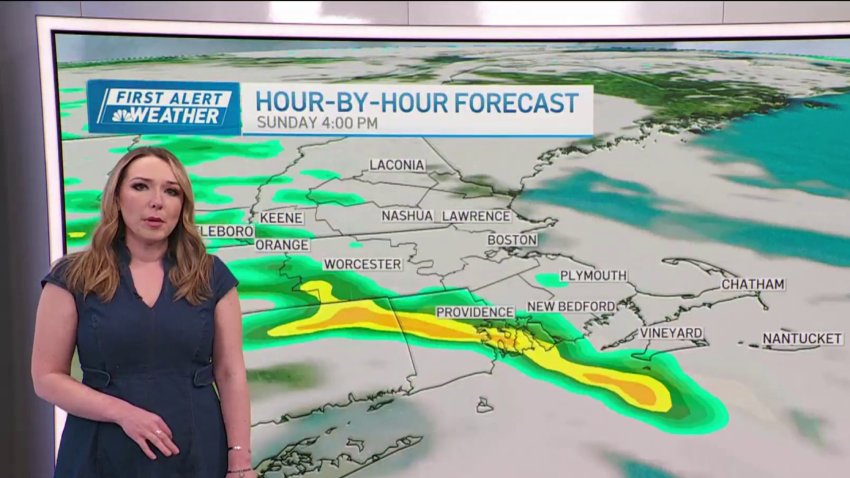
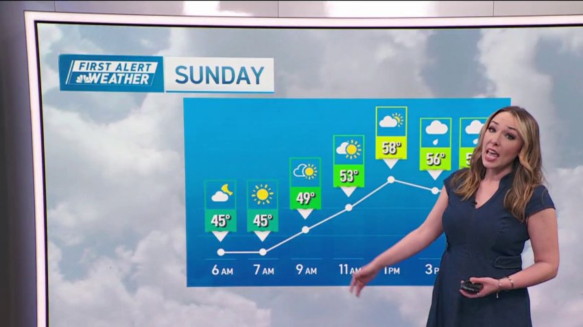
Sunday: Morning sun, afternoon clouds with some showers, breezy. Highs upper 50s.
Monday: Sunny and warm for the Boston Marathon. Highs near 65. NW wind 10 mph.
Tuesday: Sunny with highs in the mid to upper 60s. West wind 10-15 mph. -
Forecast: Mostly sunny, breezy weekend
Overnight Tonight: Mostly cloudy, less wind. Lows low 40s.
Sunday: Morning sun, afternoon clouds with some showers, breezy. Highs upper 50s. -

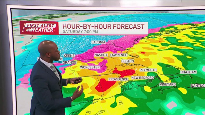
Coastal communities get ready for nor'easter
Wind and flooding are a risk on the coast as parts of New England prepare for snow.
-

NH braces for an April snowstorm as coastal communities prepare for wind
April showers bring… a nor’easter to New England. Just when you think it’s safe to put away the winter gear, from heavy jackets, to shovels and ice melt, the season strikes back. When it comes to weather in New England – you have to expect the unexpected. “We’ve already sold some rock salt today, we’ve sold some wood...
-

New Hampshire braces for an April snowstorm
While most of southern New England will see rain, in New Hampshire many are expecting an April snowstorm.
Follow NBC10 Boston on…
Instagram: instagram.com/nbc10boston
TikTok: tiktok.com/@nbc10boston
Facebook: facebook.com/NBC10Boston
X: twitter.com/NBC10Boston -
A big storm may be coming, but southern New England is still short on snow
A spring storm is heading in for our first week of April. And as models hint at snow (with major snow in the mountains up north)…we miss out again in southern New England. The entire winter into the first month of meteorological spring (March) had a huge lack of snowfall across southern New England. Boston, for example, had only 9.7”…
-
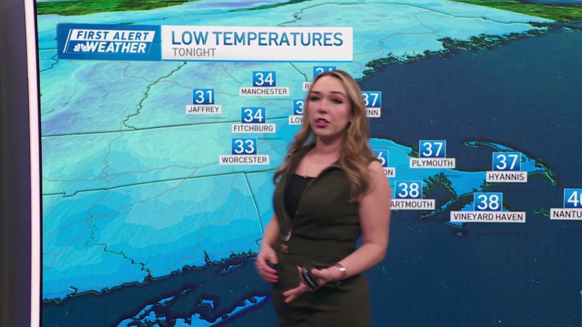
Forecast: Freezing temps overnight
Overnight Tonight: Rain clearing out. Partly cloudy skies. Temperatures near 30°.
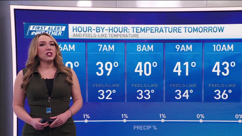
Sunday Morning: Wintry breeze. Wind Chill near 15°
Sunday Afternoon: Gusty Winds: NW 15-30mph. Mostly clear skies. High Temperature: 40°.
Monday: Plenty of Sun. Windy. High Temperature: 39°. -
FORECAST: Bitter cold follows rain
Saturday PM: Heavy rain through midnight. Overnight, temperatures fall to near 30 degrees.
Sunday: A veil of clouds, wintry breeze. Highs around 40, wind chill around 30.
Monday: Brisk wind through the day, highs in the upper 30s, feeling like the 20s. -
Forecast: Cooler temps start the work week
Overnight Tonight: Few clouds, breezy, and chilly. Lows low to mid 30s.
Monday: AM sunshine, some afternoon clouds, breezy. Highs upper 40s to low 50s. -
Forecast: Cool temps start the week
Overnight Tonight: Few clouds, breezy, and chilly. Lows low to mid 30s.
Monday: AM sunshine, some afternoon clouds, breezy. Highs upper 40s to low 50s. -

FORECAST: Rainy St. Patrick's morning
Overnight Tonight: Mostly cloudy, patchy fog, showers by daybreak. Lows in the 30s.
Sunday: AM showers, decreasing afternoon clouds, stray shower/sprinkle, breezy. Highs in the 50s. -
Forecast: Intense wind and rain overnight, snow for some in New England
Overnight Tonight: Rain develops, increasing southeast wind, gusts over 30, snow north. Lows in the 40s
Sunday: Early AM rain, windy with decreasing clouds, northwest wind gusts over 30. Highs in the 50s.Follow NBC10 Boston on…
Instagram: instagram.com/nbc10boston
TikTok: tiktok.com/@nbc10boston
Facebook: facebook.com/NBC10Boston
X: twitter.com/NBC10Boston -
Forecast: Rain develops, wind gusts increase later Saturday
Today: Some AM breaks of sun, increasing afternoon clouds. Highs in the 40s....
...
Overnight Tonight: Rain develops, increasing southeast wind, gusts over 30, snow north. Lows in the 40s...
Sunday: Early AM rain, windy with decreasing clouds, northwest wind gusts over 30. Highs in the 50s....Follow NBC10 Boston on…...
Instagram: instagram.com/nbc10boston...
TikTok: tiktok.com/@nbc10boston...
Facebook: facebook.com/NBC10Boston...
X:... -
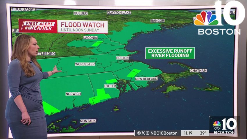
Weather forecast: Snow set to fall
Monday night: Cloudy. Predawn snow and rain starts south. Lows in the 30s. Tuesday: Early morning snow/rain to all snow, falling heavily with a gusty coastal wind and afternoon coastal flooding. Blizzard conditions possible on Cape Cod. Temperatures around freezing. Wednesday: Blustery, fair, chance flurry. Highs around 35.
-
Weather forecast: New England planning for snow
Monday night: Cloudy. Predawn snow and rain starts south. Lows in the 30s. Tuesday: Early morning snow/rain to all snow, falling heavily with a gusty coastal wind and afternoon coastal flooding. Blizzard conditions possible on Cape Cod. Temperatures around freezing. Wednesday: Blustery, fair, chance flurry. Highs around 35.
-
Snow forecast: Nor'easter changing track, but Boston set for bad weather Tuesday
Monday evening: Increasing wispy clouds. Temps in the low 40s.
Overnight Monday night: Cloudy. Predawn snow and rain starts south. Lows in the 30s. Tuesday: Early AM snow/rain to all snow, falling heavily with a gusty coastal wind and PM coastal flooding. Blizzard conditions possible on Cape Cod. Temperatures around freezing. Wednesday: Blustery, fair, chance flurry. Highs around 35.
-
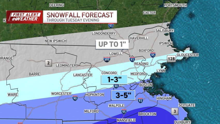
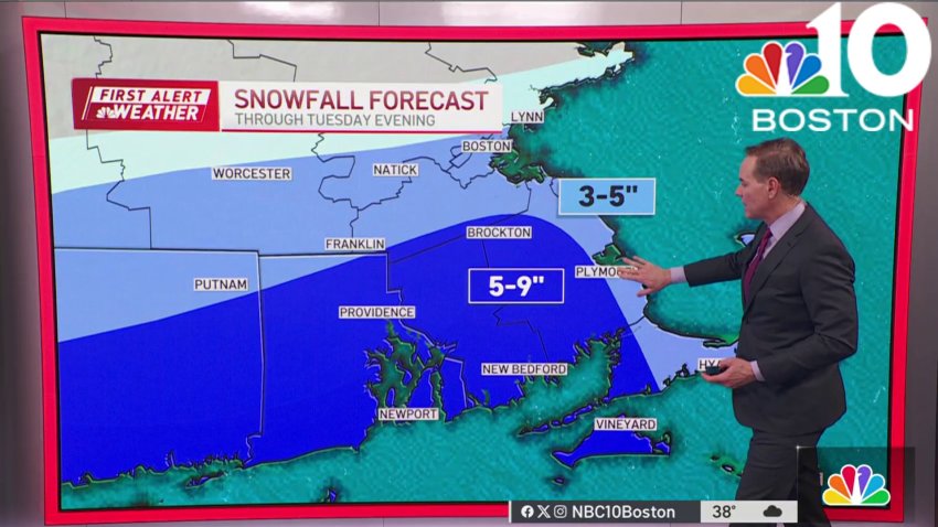
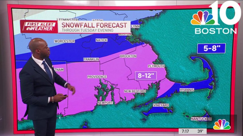
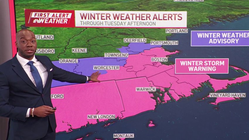
SNOW MAPS: With storm shifting, how much snow will we get from Tuesday's nor'easter?
As a nor’easter approaches Tuesday New England is preparing for a storm that could drop a foot of snow in some areas. Schools have already announced closures, with more expected as the storm moves closer, but as of Monday afternoon we’re watching some new patterns emerging that will change where we expect to see the most snowfall. The low...
-
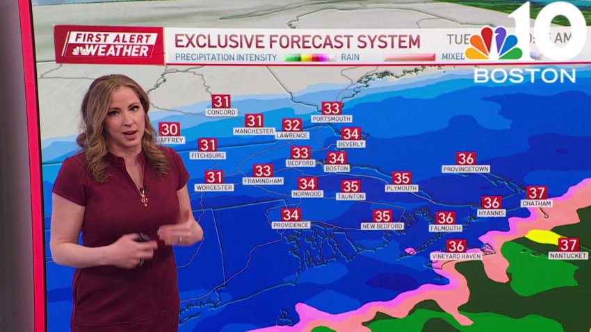
Storm to bring heavy snow, winds and coastal flooding
Monday: Sun with increasing wispy clouds. Pleasant highs 45-50.
Overnight Monday night: Cloudy. Predawn snow and rain starts south. Lows in the 30s.
Tuesday: Early AM snow/rain to all snow, falling heavily with a gusty coastal wind and PM coastal flooding. Blizzard conditions possible on Cape Cod. Temperatures around freezing.
Wednesday: Blustery, fair, chance flurry. Highs around 35. -

Blizzard of '78: 46 years later, a look back at the storm that crippled New England
Forty-six years ago, the Blizzard of ’78 was exiting New England, concluding 36 hours of aggressive snow, wind and rounds of coastal flooding that left a lasting impact on the region. Beyond its status as a significant snowstorm, the event fundamentally altered the way an entire generation interpreted major snow forecasts. The storm hit New England on Feb. 6 and…
-
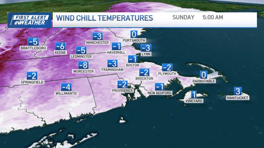
Wind chills in the single digits in New England during the weekend
Your Saturday morning begins with wind chills in the single digits above and below freezing. A frigid weekend is ahead. For Saturday, temperatures will stay 10-20 degrees below normal, with wind gusts near and above 20 mph. Cloud cover is expected due to a shortwave, limiting sunshine. Highs will be in the teens to low 20s, and it will be...
Trending
