Skip to content
Main Navigation
Search
Search for:
Local
Weather
Investigations
Videos
Sports
U.S. & World
Traffic
Newsletters
Live TV
Trending
24/7 streaming news
Trump trial
Karen Read trial
'Mazzulla' docuseries
Ana Walshe podcast
Paris Olympics
Kwani Has Questions
@Issue
NBC Sports Boston
Expand
Boston
3 hours ago
Students at Harvard, Brown join in pro-Palestinian protests across college campuses
north andover
3 hours ago
Police respond to barricaded person in North Andover
Nick Goss
5 hours ago
Game 3 takeaways: Special teams dominance lifts Bruins to 4-2 win
Arizona
3 hours ago
Arizona indicts 18 in case over 2020 election in Arizona, including Giuliani and Meado...
Boston Celtics
4 hours ago
Celtics-Heat takeaways: Miami catches fire from 3 to even series
Braintree
8 hours ago
Person grazed on I-93 in Braintree in possible road rage shooting, sources say
Israel-Hamas War
3 hours ago
Police tangle with students in Texas and California as wave of campus protest against ...
Gloucester
9 hours ago
‘Smoke screen': Gloucester harbormaster's firing draws questions and criticism...
travel
8 hours ago
Mother's warning after son's 8-month Turks and Caicos prison sentence: ‘It's n...
Phil Perry
14 hours ago
2024 NFL Mock Draft: Where Patriots stand on QB with No. 3 pick
Local
See all
Nick Goss
2 hours ago
Why Bruins should go back to Jeremy Swayman in Game 4 vs. Leafs
Boston Bruins
4 hours ago
Keefe praises Marchand's ‘elite' ability to get calls in postgame rant
Boston Celtics
4 hours ago
Jimmy Butler trolls Jaylen Brown, C's with IG post after Game 2
Most Read
travel
US tourists face 12 years in prison for accidentally bringing ammo to Caribbean island
north andover
Police respond to barricaded person in North Andover
travel
Mother's warning after son's 8-month Turks and Caicos prison sentence: ‘It's not behind us'
Parenting
Comedian Arj Barker asks breastfeeding mother to leave show after baby talked during his set
Braintree
Person grazed on I-93 in Braintree in possible road rage shooting, sources say
Boston
Students at Harvard, Brown join in pro-Palestinian protests across college campuses
Braintree
8 hours ago
Person grazed on I-93 in Braintree in possible road rage shooting, sources say
Israel-Hamas War
3 hours ago
Police tangle with students in Texas and California as wave of campus protest against ...
Gloucester
9 hours ago
‘Smoke screen': Gloucester harbormaster's firing draws questions and criticism...
travel
8 hours ago
Mother's warning after son's 8-month Turks and Caicos prison sentence: ‘It's n...
Phil Perry
14 hours ago
2024 NFL Mock Draft: Where Patriots stand on QB with No. 3 pick
Top Videos
See all
Karen Read Trial
See all
Karen Read
8 hours ago
Karen Read trial: What's next now that the jury has been seated?
local
15 hours ago
Jury selection continues in Karen Read trial
Karen Read
7 hours ago
Karen Read trial jury selected; judge open to moving courtrooms
Patriots
See all
New England Patriots
11 hours ago
Brandon Aiyuk could be best trade target for WR-thirsty Patriots
Patriots Talk Podcast
18 hours ago
Curran: Clarifying Jonathan Kraft's role in Patriots' decision-making
Phil Perry
Apr 23
Prototypical Patriots: Defensive tackle fits in 2024 draft class
Hub Today
See all
Art and Culture
10 hours ago
Let's get crafty: Exploring the House of Art & Craft in Brighton
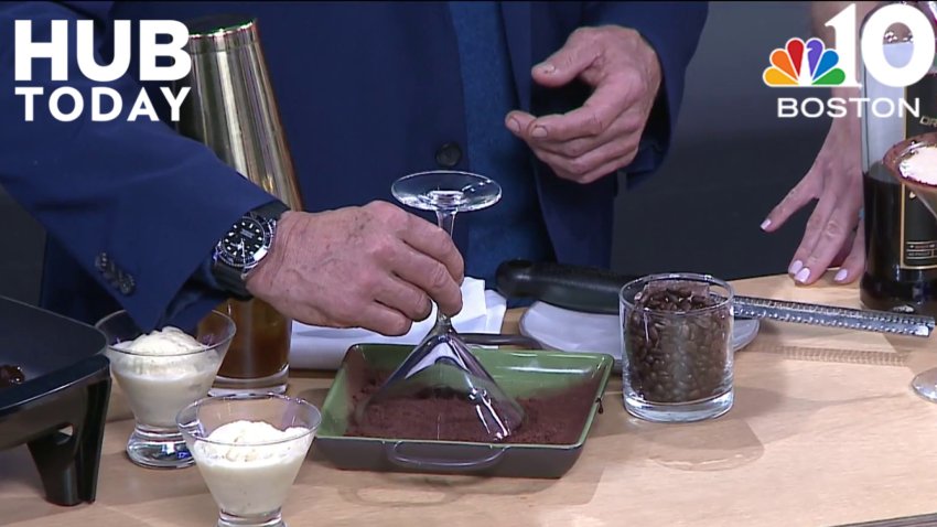
Drinks
11 hours ago
The best ways to enjoy an Espresso Martini
food pantry
11 hours ago
How the Franklin Food Pantry goes beyond the food
podcasts
11 hours ago
Chatting with co-hosts of the “I've Had It” podcast
Passover
11 hours ago
Celebrating Passover with delicious dishes
Responds
See all
travel
9 hours ago
US tourists face 12 years in prison for accidentally bringing ammo to Caribbean island
Investigations
See all
nbc10 investigators
Jun 5, 2023
How to submit tips to the NBC10 Investigators
investigations
Apr 11
Ipswich firefighter's overtime pay for hazmat response sparks controversy
To Catch a Contractor
Apr 10
Nurse moonlighting as contractor accused of financially gouging homeowners
Massachusetts
Mar 22
‘R u alive?' Texts show parents' fear in search for daughter who died of overdose
Decision 2024
See all
abortion
8 hours ago
Arizona state House passes bill to repeal 1864 abortion ban
Massachusetts
10 hours ago
Mass. lawmakers negotiating shelter bill have final deal in place
Congress
14 hours ago
Biden signs a $95 billion war aid measure with assistance for Ukraine, Israel and Taiwan
@Issue
See all
@Issue
Apr 21
@Issue: Trump “hush money” trial underway
@Issue
Apr 14
@Issue: Biden allies hope abortion measures help beat Trump
@Issue
Apr 7
Addressing a mental health crisis in Boston
U.S. & World
See all
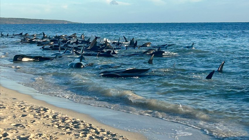
Animals and Wildlife
15 mins ago
More than 160 pilot whales beached on western Australian coast and at least 26 died, officials say
San Diego
3 hours ago
Man sentenced to 9 years for bringing 2 teen girls to San Diego for prostitution
New Mexico
5 hours ago
Search ongoing for man who may have taken homemade raft down Colorado River
Israel-Hamas War
8 hours ago
Hamas releases video of Israeli hostage Hersh Goldberg-Polin
Celebrity News
8 hours ago
Judge declines to dismiss lawsuits against rapper Travis Scott over deadly Astroworld concert
News
Entertainment
Gwyneth Paltrow is having a ‘nervous breakdown' over this parenting milestone
7 hours ago
Ryan Seacrest and Aubrey Paige break up after 3 years
8 hours ago
Kate Middleton has a new royal title that marks a first for the royal family
12 hours ago
Boston Business Journal
The first apartments at Suffolk Downs can now be rented
Apr 19
Wayfair's first branded store has an opening date
Apr 18
Get a sneak peek inside F1 Arcade's new Boston location
Apr 18
Boston Restaurant Talk
Clover Food Lab emerging from bankruptcy with expansion plans
12 hours ago
Grasshopper Vegan Restaurant in Allston is closing
18 hours ago
Providence restaurant expanding into Cambridge: report
Apr 22
Celtics
Eddie House: Celtics defense ‘a count late' in Game 2 loss to Heat
Watch
•
4 hours ago
WATCH: Jaylen explodes for 11 points in two-minute span vs. Heat
Watch
•
6 hours ago
The four best flareups in Celtics-Heat rivalry
Watch
•
8 hours ago
Red Sox
Red Sox place Brayan Bello on IL in latest blow to pitching staff
Watch
•
12 hours ago
With shades of Ellsbury, Casas injury could be a killer for Red Sox
Watch
•
Apr 23
Kutter Crawford has come out of nowhere to become MLB's best pitcher
Watch
•
Apr 23
bruins
Bruins can't afford to allow Matthews, Leafs' stars to take over series
Watch
•
16 hours ago
Bruins vs. Leafs Game 3 lineup: Projected lines, pairings, goalies
Watch
•
14 hours ago
‘Terrific' Ullmark was Bruins' best player in Game 2 loss to Leafs
Watch
•
Apr 23
Close Menu
Search for:
Meet the Team
Local
Weather
School Closings
Weather Alerts
Climate 2023
Investigations
NBC10 Boston Responds
Submit a tip
Video
Health
Traffic
NBC Sports Boston
Sports
Celtics
New England Patriots
Bruins
Red Sox
Entertainment
Hub Today
About NBC10 Boston
Our News Standards
TV Listings
Submit a Tip
Submit a Consumer Complaint
Submit Photos and Video
Newsletters
Download Our Apps
Cozi TV
Follow Us
Facebook
Instagram
TikTok
Contact Us
 Contact Us