
-
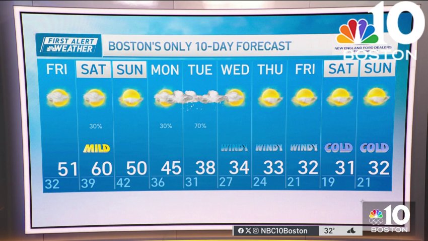
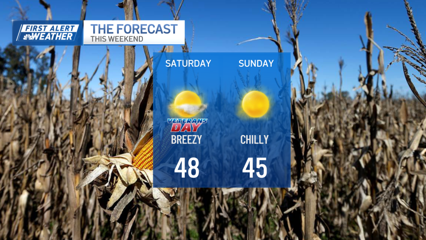
Forecast: Record warmth Saturday and mild Sunday ahead but all eyes on Tuesday
Overnight Tonight: Stray shower early, lots of clouds, some fog. Lows upper 30s to 40.
Sunday: Clouds with breaks of sun. Highs mid 40s to 50.Follow NBC10 Boston on…
Instagram: instagram.com/nbc10boston
TikTok: tiktok.com/@nbc10boston
Facebook: facebook.com/NBC10Boston
X: twitter.com/NBC10Boston -
Record warmth for some on Saturday before snowstorm early in the week
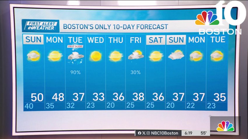
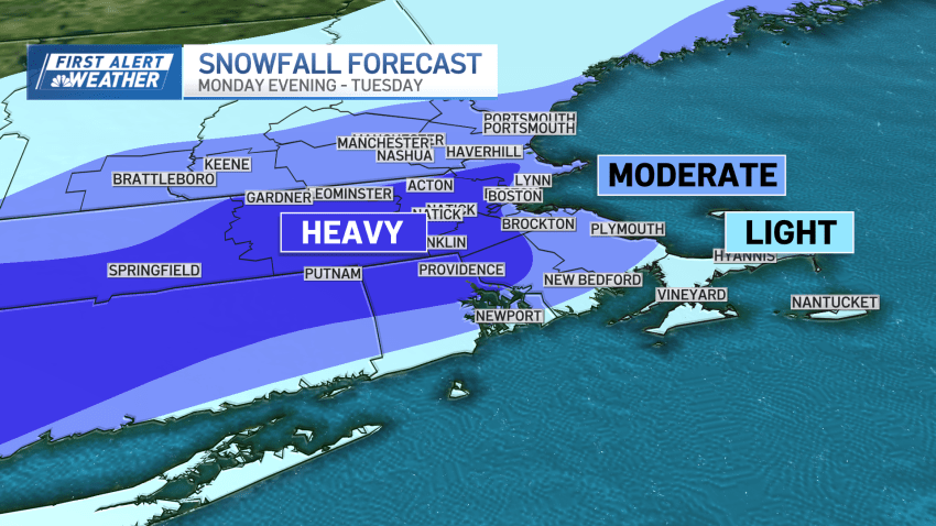
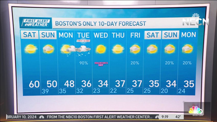
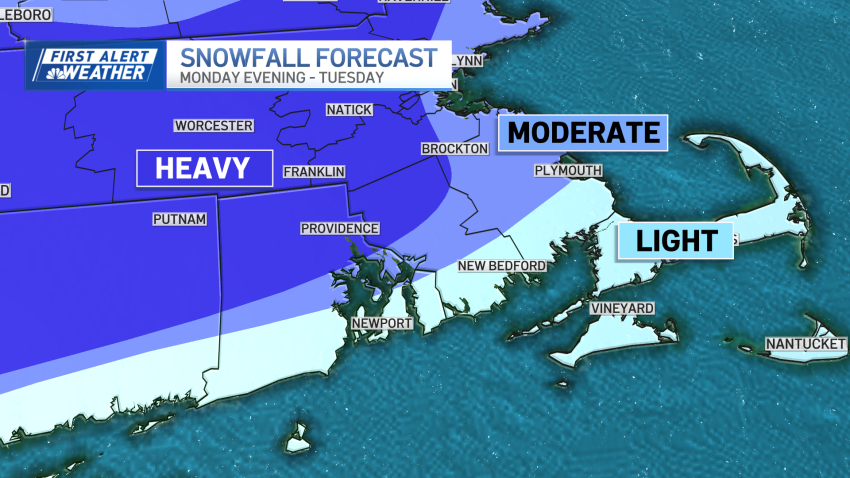
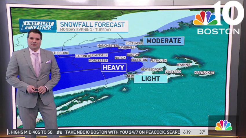
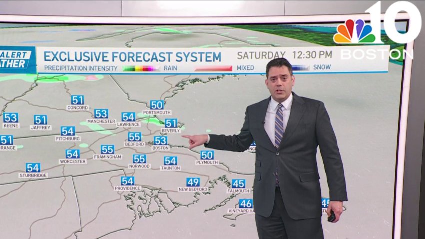
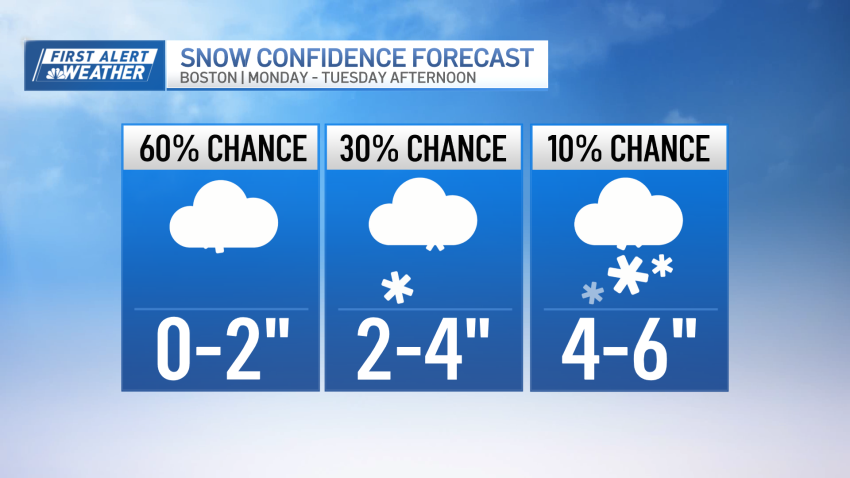
Here’s a look at our early snow map for Tuesday We’re on our way to a record warm afternoon as high temperatures reach the upper 50s to low 60s from Boston points south and west, and into the Merrimack Valley. The record high for today at Logan Airport is 60 degrees which was set back a year ago. The...
-
Warm weekend before possible snowstorm early in the week
Today: Sun & clouds, warm, evening showers, rumble of thunder inland. Record highs near 60. Overnight Tonight: Stray shower early, lots of clouds, some fog. Lows upper 30s to 40. Sunday: Clouds with breaks of sun. Highs mid 40s to 50.
-
Warm weekend as we await snowstorm early next week
Here’s a look at our early snow map for Tuesday We’re really ramping up the weather intensity in the coming days. The pendulum swings from warm to cold and the pattern spins up a robust winter storm by Monday night. Then it’s all about the cold into Valentines Day and beyond, so whatever snow we receive is likely to...
-
Possible snow early next week in New England
Today: Sun & clouds, warm, evening showers, rumble of thunder inland. Record highs near 60....
...Overnight Tonight: Stray shower early, lots of clouds, some fog. Lows upper 30s to 40....
...Sunday: Clouds with breaks of sun. Highs mid 40s to 50....
...Follow NBC10 Boston on…...
Instagram: instagram.com/nbc10boston...
TikTok: tiktok.com/@nbc10boston...
Facebook: facebook.com/NBC10Boston...
X:... -
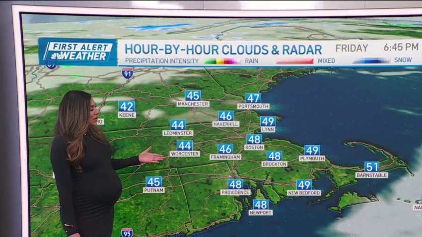
It'll feel like spring in Boston Saturday, with temps near 60
Friday: A round of AM clouds, flurry, sprinkle to breaks of sun. Highs near 50.
Overnight Friday night: Mostly cloudy. Lows in the 30s.
Saturday: Sun & clouds, mild, late & evening showers. Record highs near 60.
Sunday: Fair. Highs 45-50. -
Temps will continue rise into the weekend in New England
Friday: A round of AM clouds, flurry, sprinkle to breaks of sun. Highs near 50.
Overnight Friday night: Mostly cloudy. Lows in the 30s.
Saturday: Sun & clouds, mild, late & evening showers. Record highs near 60.
Sunday: Fair. Highs 45-50. -
Record-setting weekend warmth, but a storm is headed our way
Temperatures continue to climb Friday with a sun/cloud blend. The deciding factor in reaching 50 (or better) will be the sun and the wind direction. South winds will favor cooler readings on the Cape(s)/Islands and across most of southeast Massachusetts. Boston could sneak into the elite “fitty” club, but it may be a challenge. But we’re on firm ground...
-
Weather forecast: Highs around 50
Thursday night: Clouds increase. Lows around 30. Friday: Morning mixed shower to emerging sun. Highs near 50. Saturday: Variable clouds, scattered late day and evening showers. Near-record highs close to 60.
-
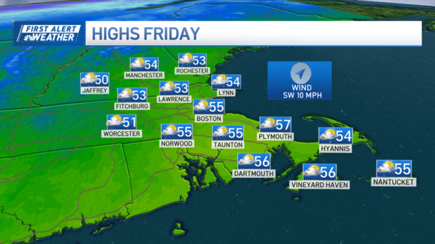
Mild start to December but morning sun gives way to clouds, chance of rain
The mild temperatures peak Friday as sunshine holds sway through the morning. Although limited these days, it should be enough to boost us into the low and mid-50s this afternoon. Breezes from the southwest continue as the clouds slowly increase from the west. Showers are moving east as well. While this isn’t a big rainmaker, we should see some...
-
Friday starts off with sun, showers come in the afternoon
Friday: Sunny start, showers by late day into the evening. Highs in the 50s.
Overnight Tonight: Showers. Lows in the 40s.
Saturday: Mostly cloudy. Morning showers depart for a mostly dry day. Highs in the 50s.
Sunday: Rain likely, North Country mountain snow. Highs in the 40s. -
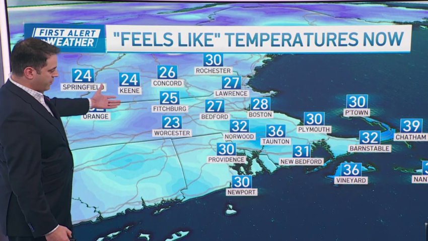
Brrr! Chilly, wintry feeling day on Tuesday
Today: Clouds & sun, a few snow/rain showers, gusty & wintry wind. Highs 35-40, wind chill near 30. Overnight Tonight: Clearing. Lows in the 20s, wind chill 10s. Wednesday: Fair, continued chilly with highs 35-40, wind chill near 30. Thursday: Sunny, not as cool. Highs in the 40s.
-
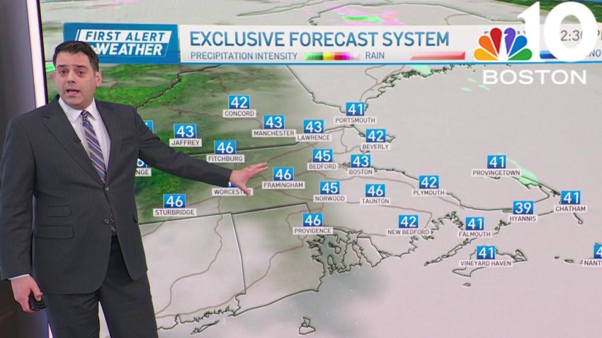
Tuesday sees cold temperatures and wind chills, isolated flurries for some
As promised, the colder air has arrived. More importantly, super cold air is above us right now. That will foster cloud development, and with some snow showers reaching into western Massachusetts and Vermont from Lake Ontario, we could see a few flurries survive all the way to the Worcester Hills or southern New Hampshire later Tuesday afternoon. Wind chills remain…
-
Limited sun, cold weather Friday. Here's what you can expect
Cold air will take a stutter step Friday before it pounces on us this weekend. Despite the high clouds — and limited sun — we’ll manage to make it into the low and mid-50s. Gusty winds will sweep across the area, too. Some may top 25 miles per hour in the northern Massachusetts and southern New Hampshire. Skies clear Friday…
-
Stay warm because Friday will be cloudy and cold
Today: Mostly cloudy, highs in the low 50s, breezy gusting 25 mph.
Overnight: Lows in the mid-30s inland, upper 30s in Boston.
Saturday: Highs in the upper 40s, bright, breezy.
Sunday: Frosty morning. Highs in the lower to mid-40s, sunny skies. -
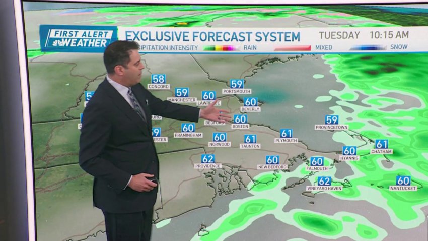
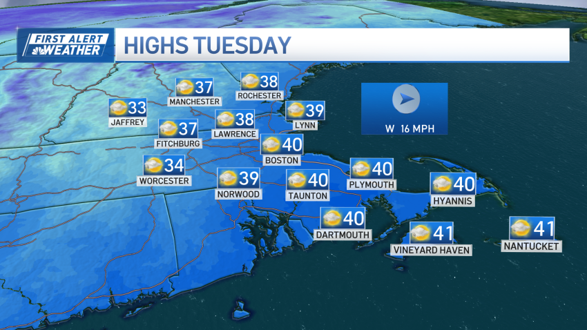
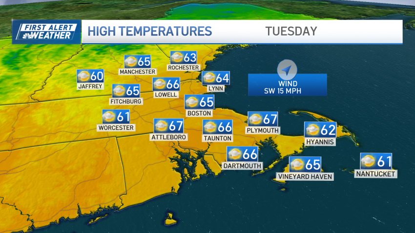
Tuesday's temperatures expected to be well into the 60s
Today: Early showers to emerging sun and a mild breeze. Quick late day shower. Highs in the 60s. Overnight Tonight: Partly cloudy with a cool breeze. Lows in the 30s. Wednesday: Brisk sun with a nippy wind. Highs only in the 40s. Thursday: Mixed rain/snow showers to rain showers. Highs in the 40s.
-
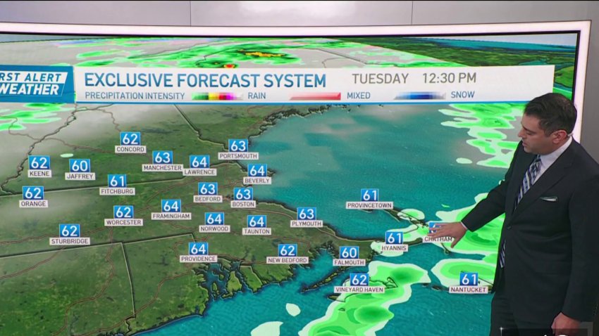
Tuesday's air almost feels summery
Today: Early showers to emerging sun and a mild breeze. Quick late day shower. Highs in the 60s. Overnight Tonight: Partly cloudy with a cool breeze. Lows in the 30s. Wednesday: Brisk sun with a nippy wind. Highs only in the 40s. Thursday: Mixed rain/snow showers to rain showers. Highs in the 40s.
-
Enjoy mild temperatures Tuesday — they won't last
There’s a ton of mild air flowing into New England this Tuesday morning, boosting our temperatures well into the 60s by this afternoon on the heels of a stiff southwest wind. This is a one-day foray into the mild air, as cold air is already rushing in across westernmost New York and southern Ontario. That cold will sweep in...
-
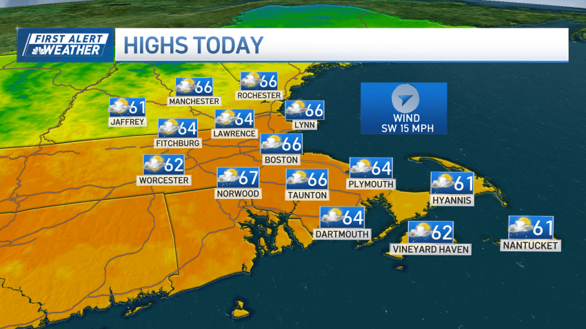
And just like that, milder temperatures are gone for your Monday
Sunday’s highs in the 60s had many wondering if this was the start of another autumn warm spell. But just like that, the winds of change sent a cold front through the region by late afternoon, and we were in a temperature tailspin as the sun dropped below the horizon (4:30-ish these days). We’re closer to November reality on...
Trending
