
-
Less rain in the forecast as we go throughout the weekend
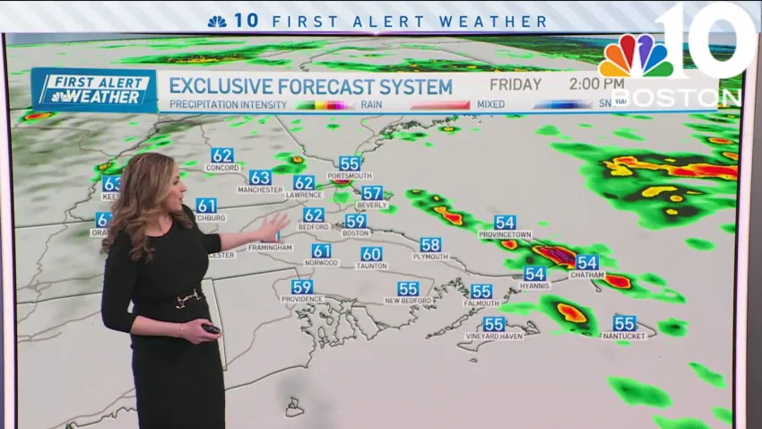
Friday: First Alert Day. Morning Fog and Rain. Isolated thunderstorm. Highs in the upper 50s.
Overnight Friday night: Clouds breaking. Breezy Winds: 20-25mph. Lows near 48 degrees.
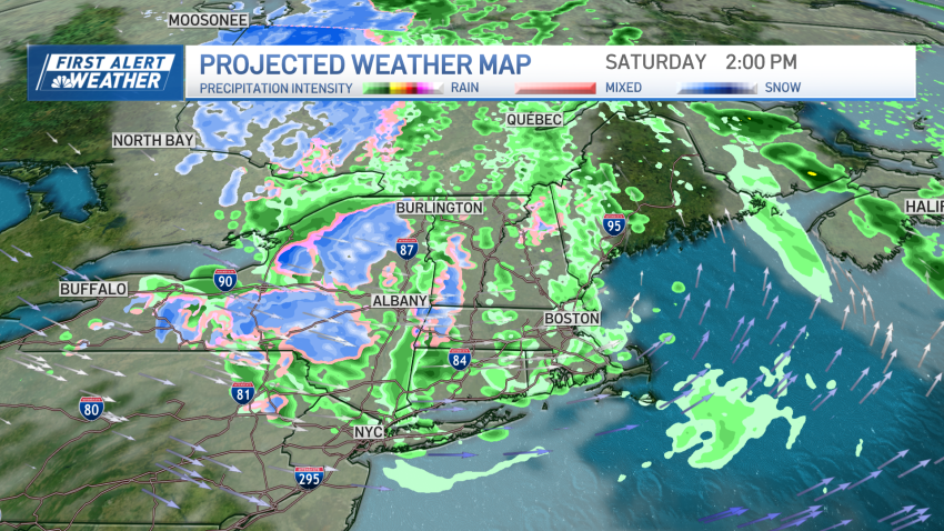
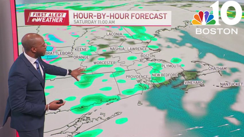
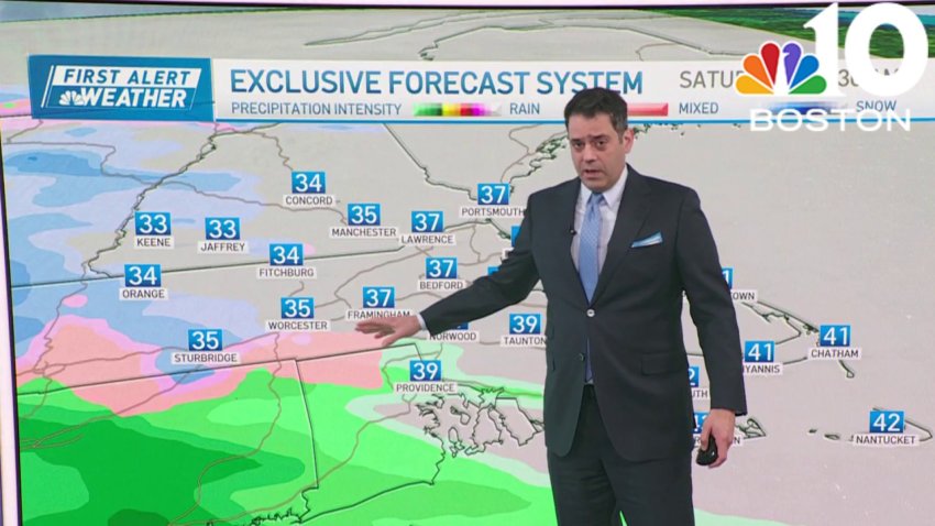
Saturday: Partly Cloudy. Highs near 55 degrees.
Sunday: Mostly sunny. Evening Shower. Highs near 62 degrees. -
System to bring cool air, rain this weekend as it continues to move through northeast
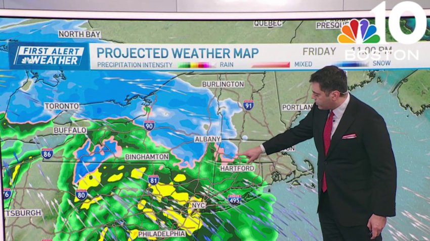
A system continues to move through the northeast, bringing us some waves of rain through part of this weekend. Continuing Friday, the main line of heavy rain and wind has moved through Friday morning. We will see some clearing skies this afternoon while temperatures stay in the 60s and dewpoints remain soupy in the 50s. As a cold front...
-
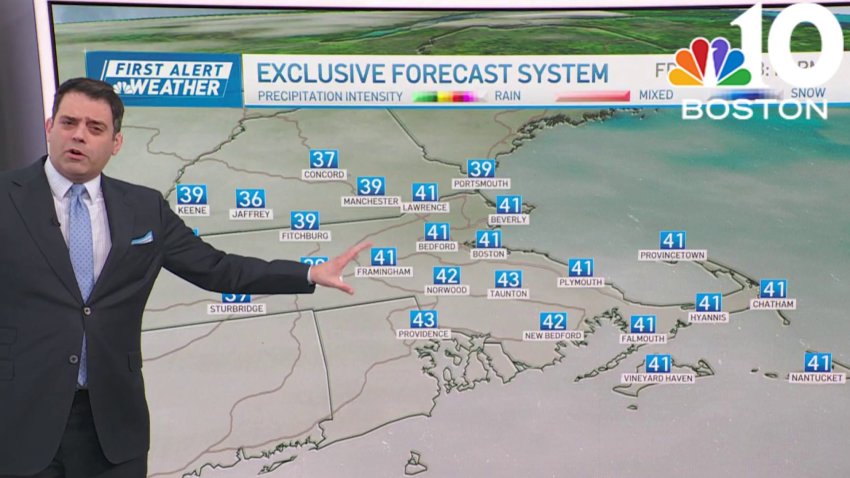
Downpours and gusty winds strike Boston Friday
Friday: First Alert Day. Morning Fog and Rain. Isolated thunderstorm. Highs in the upper 50s.
Overnight Friday night: Clouds breaking. Breezy Winds: 20-25mph. Lows near 48 degrees.
Saturday: Partly Cloudy. Highs near 55 degrees.
Sunday: Mostly sunny. Evening Shower. Highs near 62 degrees. -

Wind rips off part of Gardner Fire Department's roof
Security footage captured part of a Massachusetts fire station’s roof being blown off early Thursday morning as heavy winds whipped. The Gardner Fire Department shared video Thursday showing a piece of standing seam metal roof flying out of place and crumbling. The incident caused major damage, the fire department said, explaining that a wind gust of about 60 mph was…
-

WATCH: Wind blows off part of Gardner Fire Department's roof
Video shows a fire station in Gardner, Massachusetts, being damaged by the wind early Thursday morning.
-
Plowable snow falling across New England
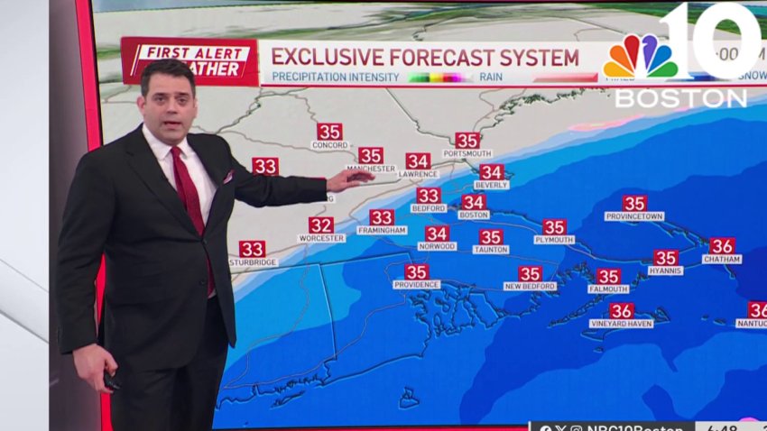
Tuesday: Snow in southern New England, heavy in southeast MA, RI & CT. Windy at the coast with coastal flooding. Highs in the 30s.
Overnight Tuesday night: Clearing, icy spots. Lows in the 20s.
Wednesday: Sun & clouds, chance of a flurry, blustery. Highs in the 30s.
Thursday: Sun to clouds, evening and night snow showers. Highs near 40. -
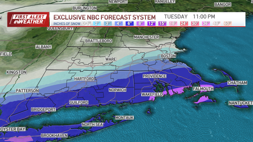
Nor'easter arrives, bringing plowable snow to parts of Mass.
There are times when the forecast delights and times when it defies logic. This is one of the latter. Guidance was very confident in most of Massachusetts seeing 6 to 12 inches of snow. As the track shifted south, the confidence vanished. Why the shift? Why the backpedaling? It’s easy to say, “Weather is variable. Changes happen.” But the crux…
-
Sunny in Boston Monday, with high temps in the mid-40s
Monday: Sun with increasing wispy clouds. Pleasant highs 45-50.
Overnight Monday night: Cloudy. Predawn snow and rain starts south. Lows in the 30s.
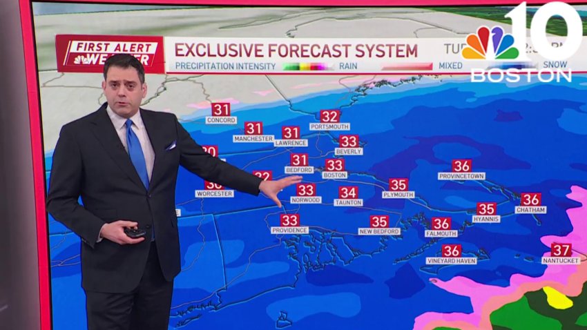
Tuesday: Early AM snow/rain to all snow, falling heavily with a gusty coastal wind and PM coastal flooding. Blizzard conditions possible on Cape Cod. Temperatures around freezing.
Wednesday: Blustery, fair, chance flurry. Highs around 35. -
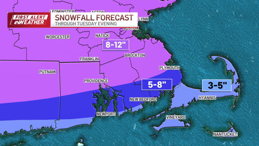
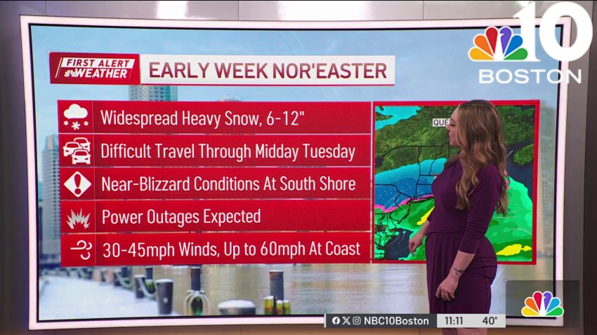
Nor'easter to bring heavy 8-12 inches of snow, wind and coastal flooding to Mass. Tuesday
A mild Monday ahead of a potent nor’easter that will be bringing heavy snow, wind and coastal flood potential for Tuesday. By Tuesday’s morning commute, whiteout conditions are likely. Very difficult morning travels that will bleed into the afternoon. This is across the region. Winds will gust above 30 miles per hour, with up to 55 mph gusts along the…
-
Forecast: Widespread heavy snow expected Tuesday
Overnight Tonight: Scattered clouds, chilly. Lows low 30s.
Monday: Some AM sun, increasing PM clouds, cool. Highs mid 40s.Follow NBC10 Boston on…
Instagram: instagram.com/nbc10boston
TikTok: tiktok.com/@nbc10boston
Facebook: facebook.com/NBC10Boston
X: twitter.com/NBC10Boston -
Storm to bring windswept downpours Saturday morning
Friday: Sun & clouds. Highs in the 40s.
Overnight Friday night: Rain and northern snow arrives, wind increases. Temperatures around 40, 30 north.
Saturday: AM rain/damaging wind gusts go to PM breaks of sun & a few showers with pockets of coastal flooding. Highs in the 50s.
Sunday: Blustery, passing flurries. Highs near 40, wind chill 30. -
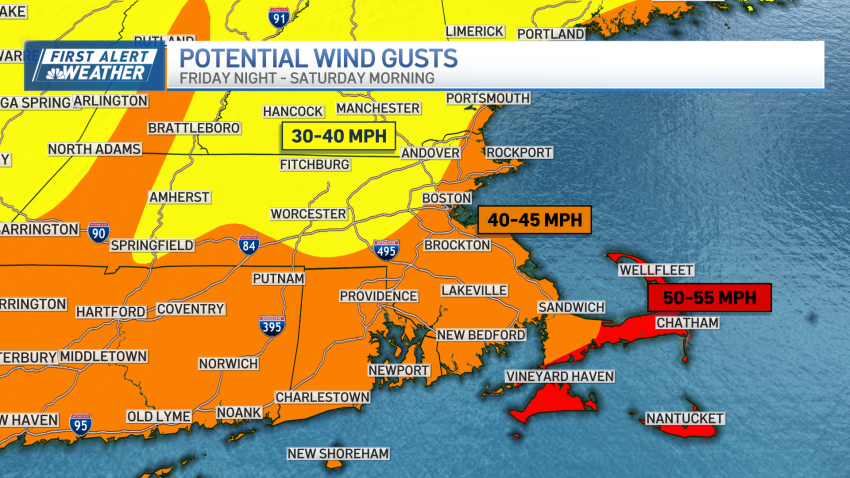
Weekend storm brings more rain, wind and flood concerns
Here we go again, into another nasty rain/windstorm on the weekend. There are some similarities to Wednesday’s event, but there are a couple of differences, too. One of the major issues is the coastal flooding. We’re in the new moon cycle, and this time around, the tides will be running higher than on Wednesday. We’re expecting the coastal flooding...
-
Flooding a concern, as more rain and wind arrive this weekend
Friday: Fair. Night rain and northern snow arrives. Highs in the lower 40s. Saturday: Early morning rain and strong wind gusts depart for a few showers, breaks of sun and highs in the 50s.
-
Flooding a concern as next storm brings more rain to our region
Thursday: Sun & clouds, breezy, chance PM flurry north. Highs in the lower 40s for most....
Overnight Thursday: Clearing after an early sprinkle or flurry. Lows around 30, 20s north....
Friday: Fair. Night rain and northern snow arrives. Highs in the lower 40s....
Saturday: Early AM rain and strong wind gusts depart for a few showers, breaks of sun and highs in the... -
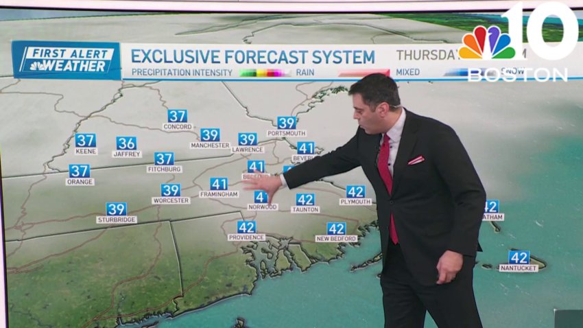
Mix of clouds, sun Thursday; another storm arrives this weekend
Thursday: Sun & clouds, breezy, chance PM flurry north. Highs in the lower 40s for most....
Overnight Thursday night: Clearing after an early sprinkle or flurry. Lows around 30, 20s north....
Friday: Fair. Night rain and northern snow arrives. Highs in the lower 40s....
Saturday: Early AM rain and strong wind gusts depart for a few showers, breaks of sun and... -
A mix of clouds and sun Thursday; next storm system arrives this weekend
Coastal flooding, inland flooding, wash outs, saturated yards, will we catch a break? After the next storm, yes. But we’ll also go into the deep freeze (better than super-soaking rainstorms, I suppose). Weak disturbance moving through Thursday will increase the clouds and possibly pop out a shower later Thursday afternoon. In contrast, Friday is bright, dry and not-so-cold. Highs...
-

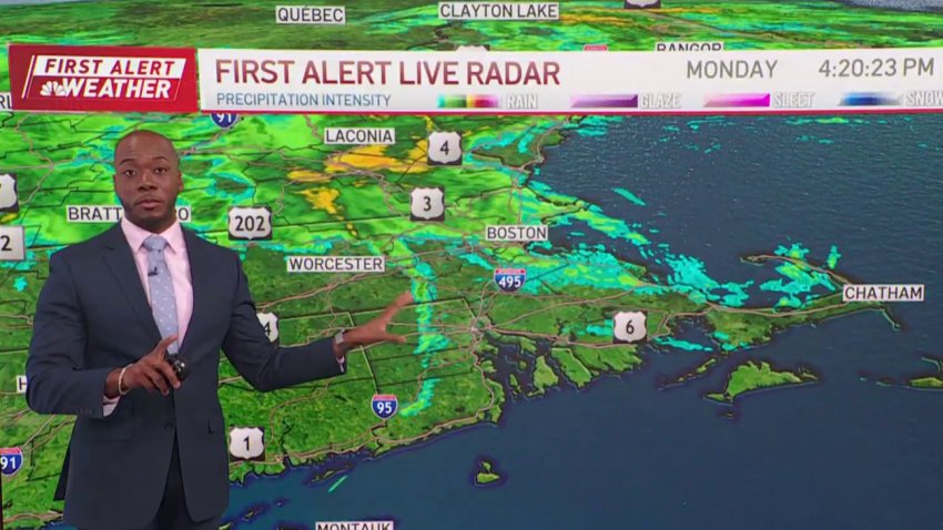
Strong winds bring down trees as heavy rain causes flooding
Storms caused damage across New England Monday, causing damage and leaving many without power.
-
Weather forecast: Showers clearing
Monday night: Partly cloudy. Lows in the 40s. Tuesday: Sun and clouds, cooler. Highs in the 40s. Wednesday: Sunny and cool. Highs 40-45.
-

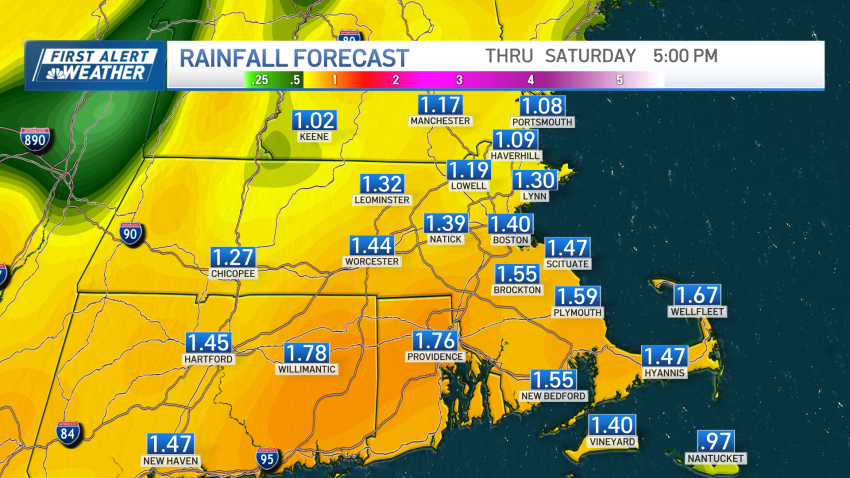
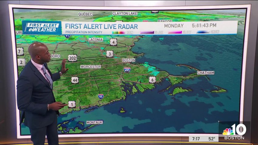
How much rain fell Monday in Boston? Explore a rainfall map
Use the map to explore rainfall totals from around the region, and scroll below it for a list of the places with the biggest rainfall totals and fastest wind speeds
-
First Alert Forecast: When the storm will subside in Boston
Overnight Monday night: Partly cloudy. Lows in the 40s. Tuesday: Sun and clouds, cooler. Highs in the 40s. Wednesday: Sunny and cool. Highs 40-45.
Trending
