
This past weekend’s rain changed the landscape for much of New England, not only adding one to three inches of much-needed rain to the water table with locally higher amounts, but also knocking down the pollen count and decreasing brush fire danger.
There’s good reason to believe we’ve seen the worst of both pollen and fire danger for the season. Although pine pollen has yet to come out and will be impactful for those with allergies, the assault of nearly every other kind of pollen with no showers to cleanse the air and ground over the last two weeks is over and those other pollen types are decreasing.
As for brush fires, this weekend’s soaking rain added moisture to parched forest and field floors, and with leaves now in bloom, shade cast on the ground will slow the drying process. As a familiar weather pattern featuring a large dome of high pressure building over Quebec launches a northeast wind into New England, building lower atmosphere pollution should decrease for a fresher air as Monday wears on, though high-altitude smoke from western Canada wildfires has returned for the third time in as many weeks, giving the sky a hazy appearance.
Get Boston local news, weather forecasts, lifestyle and entertainment stories to your inbox. Sign up for NBC Boston’s newsletters.
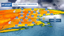
That smoke, too, should thin later Monday as fresher air arrives even aloft. Fair weather clouds Monday afternoon could produce a late day shower or sprinkle in the hills of western New England, while the persistent northeast wind has an impact on temperature, keeping coastal communities including Boston cooler than inland towns as the wind blows across ocean water still only in the 50s, and this is expected to be the case both Monday and Tuesday.
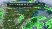
Wednesday brings a shift in wind direction from the south and southwest, meaning widespread 70s, though the milder air will be relatively short-lived with a pronounced cold front dropping south Wednesday afternoon to night, carrying a band of showers with it and opening the door to cooler air Thursday similar to the air that starts the week. A pop-up shower is still possible Thursday with lingering atmospheric energy aloft, then attention for the holiday weekend turns to our south. A large, potent upper-atmosphere disturbance will slow markedly over the southeast United States, spurring storm development between the southeast and Mid-Atlantic Friday into Saturday.
Local
In-depth news coverage of the Greater Boston Area.


Concerning to us: the storm-steering jet stream winds aloft are pointing from north to south up the East Coast, which would encourage moisture to follow suit. What may be a saving grace for at least part if not all of our Memorial Day Weekend is that the jet stream, after flowing north up the coast, is expected to hook right near or over New England, which would limit northward extent of the showers associated with the storm.
For now, our First Alert forecast calls for a dry start to the holiday weekend with increasing clouds Friday and Saturday, then a building chance of showers Sunday and Monday. That said, this hinges entirely on the progression of that storm and exactly where it develops and we’ll certainly keep you posted.
